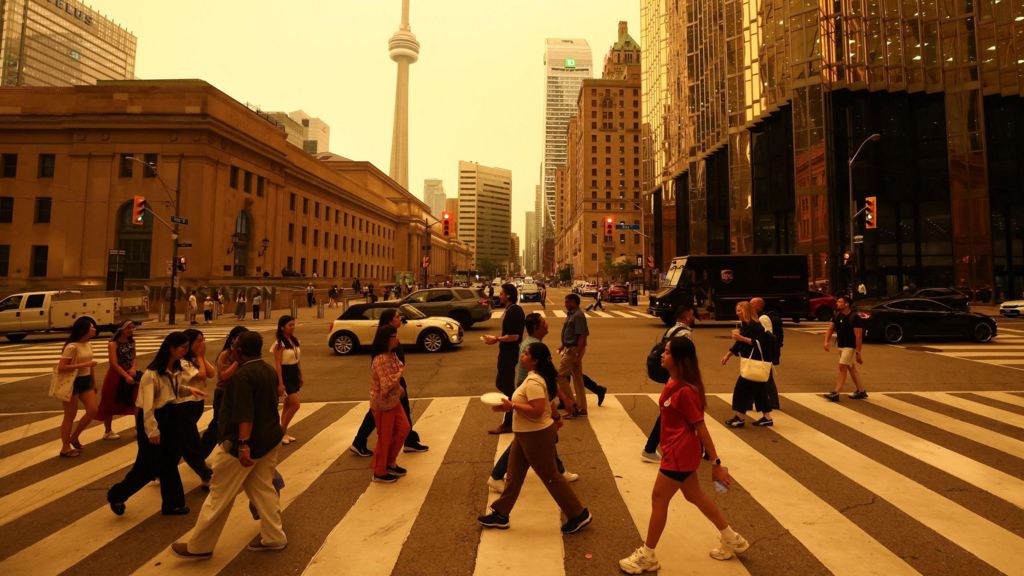
A sprawling wave of hazardous wildfire smoke originating from hundreds of active blazes across northern Canada and the upper U.S. Midwest is set to degrade air quality across major Northeast North American cities for the entirety of this week, forcing public health warnings, community evacuations and emergency response mobilization. As of the latest update from the Canadian Interagency Forest Fire Centre, 850+ wildfires are burning actively across Canada, with nearly 200 of these concentrated in the province of Ontario. In neighboring northern Minnesota, 17 uncontained blazes have prompted a state emergency declaration to speed up fire suppression resources.
Most of Ontario’s wildfires are burning in remote, forested regions north of Lake Superior, overlapping with protected national park lands and Indigenous First Nation territories. Six Ontario communities are currently under mandatory evacuation orders, with confirmed property damage reported. Grand Council Chief Linda Debassige confirmed in a Wednesday statement that the remote Namaygoosisagagun First Nation has been left devastated by a fast-moving, unanticipated wildfire that destroyed multiple residential homes and key community infrastructure.
While seasonal wildfires are a regular occurrence in Canada’s boreal forest ecosystems, the sharp spike in active outbreaks over recent weeks is being driven by extreme weather conditions linked to a stationary heat dome over the region. Climate experts from the U.S. National Interagency Fire Centre and Natural Resources Canada confirm that sustained record-breaking heat in late June, paired with rainfall well below the 30-year average, created tinder-dry conditions primed for rapid fire spread. The heat dome, a stagnant mass of high pressure that traps warm air and smoke close to the ground, pulls excess moisture from soil and vegetation, turning plant matter into ready fuel for blazes. Periodic instability within the heat dome also triggers thunderstorms that generate strong gusty winds, which fan fire expansion and push smoke plumes across vast distances.
Satellite imagery from the past three days shows prevailing wind patterns carrying smoke primarily southeast from Ontario’s fire zones, blanketing Toronto, upstate New York, and reaching as far east as Boston. Global air quality tracker IQAir has currently ranked Detroit, Toronto, and Minneapolis among the three cities with the worst air pollution levels on Earth. Wildfire smoke carries a toxic mix of fine particulate matter (PM2.5), nitrogen dioxide and other pollutants that pose severe risks to human health. New York State Department of Health Commissioner Jim McDonald explained in a public social media briefing that these microscopic particles penetrate deep into the lungs’ smallest airways, triggering harmful systemic inflammation. The World Health Organization notes that smoke exposure worsens pre-existing respiratory conditions, heart disease, kidney disorders and eye irritation. Emergency workers, children, people with chronic illnesses and elderly residents are the most vulnerable to adverse health impacts, as children face additional risk from smoke that settles closer to ground level.
Local governments across the affected region have issued orange air quality alerts, advising residents to avoid strenuous outdoor activity, stay indoors with closed windows, and wear properly fitted, government-certified N95 or KN95 masks when going outside. These masks can filter up to 95% of fine particulate matter, though health officials warn the public to avoid uncertified counterfeit masks widely sold online. Many municipalities have activated full air quality emergency protocols and set up free mask distribution sites at local community centers.
Forecasters project that shifting wind currents will push the smoke plume further south into Virginia and portions of North Carolina, with air quality worsening in those regions by Friday. A second, separate smoke plume is forecast to reach New York City and Boston by late Thursday. New York State Department of Environmental Conservation Commissioner Amanda Lefton warned that visible smoke will cover most of the state, with impacts likely lasting for multiple days and potentially bringing even worse air quality than current levels. There is growing concern that smoke may still linger in the New Jersey region by Sunday, when the FIFA World Cup final is scheduled to take place at open-air MetLife Stadium.
By Monday, a forecast shift in wind direction is expected to bring partial relief to most affected U.S. cities. However, long-term seasonal outlooks warn that elevated wildfire risk will persist through July and August across Ontario, Quebec and Canada’s Northwest Territories.
Wildfire experts note that while blazes are a natural part of boreal forest ecology, their frequency and severity have grown dramatically in recent years, a trend tied directly to human-caused climate change. The 2023 Canadian wildfire season burned 15 million hectares — an area larger than the entire country of England — while the 2025 season scorched 8.3 million hectares, making it one of the worst on record. Approximately half of all Canadian wildfires are ignited by lightning, with the remainder caused by human activity, but drier conditions driven by rising global temperatures amplify fire risk. Milder winter temperatures linked to climate change also reduce snow cover, which normally reflects solar radiation to cool the landscape; less snow leads to warmer spring temperatures, earlier plant growth, and more dry fuel available for wildfires once summer begins.
Residents can check the latest local air quality alerts through official government portals for Canada and the United States.