分类: environment

  • A conflict over cattle in Brazil’s Amazon highlights tensions for Indigenous peoples

    A conflict over cattle in Brazil’s Amazon highlights tensions for Indigenous peoples

    Nestled between the Javae and Araguaia rivers in northern Brazil, Bananal Island — the world’s largest river island — has become the epicenter of a contentious national debate that encapsulates the complex tradeoffs between environmental protection, Indigenous sovereignty and the economic power of Brazil’s massive agribusiness sector.

    Last year, federal environmental authorities ordered all commercial cattle herds removed from the island’s legally protected Indigenous territory. The order argued that the land is permanently reserved for Indigenous communities and biodiversity conservation, and that unregulated cattle grazing by non-Indigenous ranchers was not only illegal under Brazilian law, but also a major driver of widespread habitat degradation across the island.

    Wranglers successfully moved more than 100,000 cattle off the island during a period of low river levels to comply with the ruling, but the removal has triggered unforeseen economic upheaval for Indigenous residents who had become dependent on revenue from leasing tribal land to outside ranchers for decades.

    The situation lays bare the persistent challenge of reconciling three competing priorities that define environmental policy in Brazil: curbing Amazon deforestation, upholding Indigenous territorial rights, and accommodating the demands of agribusiness — one of the country’s most politically influential economic sectors. As the world’s top beef exporter, Brazil accounts for roughly 20% of global beef production, with the industry contributing 6% to the nation’s total gross domestic product.

    Conservation researchers widely recognize protected Indigenous territories as one of the most effective tools to reduce deforestation in the Amazon, the world’s largest rainforest and a critical global climate regulator. Even as Brazil has made notable progress cutting overall deforestation rates in recent years, cattle ranching remains the single largest driver of forest loss across the country. To create new grazing pastures, ranchers clear large swathes of native forest, replacing carbon-absorbing trees with methane-emitting cattle — a dynamic that accelerates global climate change while threatening native biodiversity. Data from MapBiomas, a non-profit land use tracking organization, shows Tocantins state, where Bananal Island is located, recorded among the highest deforestation rates in Brazil in 2025.

    Brazilian law strictly prohibits large-scale commercial activity on designated Indigenous lands, allowing cattle rearing only for small-scale subsidence use by tribal communities. For decades, however, an informal leasing system operated openly on parts of Bananal Island. Non-Indigenous ranchers paid village leaders roughly 15 reais ($3) per head of cattle monthly — a fraction of the 60 reais ($12) per head typical for grazing leases outside the territory. At its peak, when more than 100,000 cattle grazed on the island, monthly leasing revenue reached 1.5 million reais ($290,000), which was distributed through tribal leadership to local community associations.

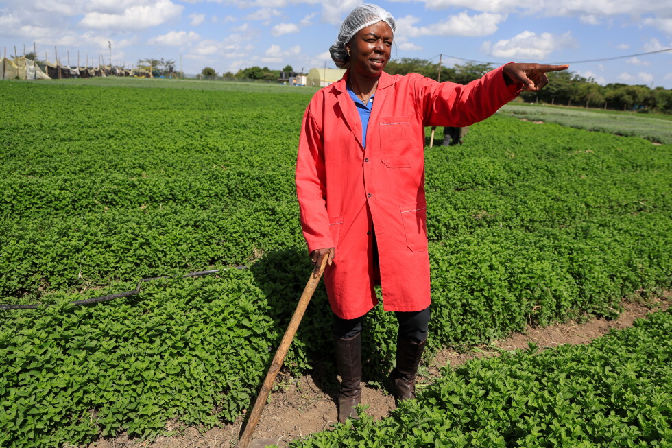
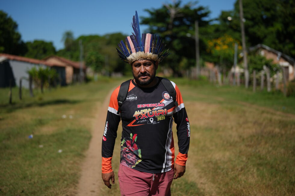
    “Cattle, over the years, have covered many of our community’s expenses,” explained Cleiton Javae, chief of the Txuiri village, one of more than 40 Indigenous communities on the island home to roughly 5,000 total residents. Javae noted the revenue funded critical local needs including school supplies, medical care, transportation and traditional cultural festivals. But critics of the informal system point to deep structural inequities: much of the revenue was concentrated among a small group of tribal leaders, leaving many community members in poverty. “The law requires consultation and shared benefits,” said Leandro Milhomem, head of IBAMA, Brazil’s federal environmental agency, in Tocantins. “Instead, some chiefs had significant resources while, in the same community, children died of malnutrition.”

    Indigenous residents also told the Associated Press that ranchers fenced off large sections of the island to contain their herds, blocking communal access to traditional subsistence farming areas. Even leaders who supported the original leasing agreements acknowledge the system spiraled out of control, with ranchers bringing far more cattle onto the island than they initially declared. “The situation became unsustainable, and removing the cattle was the only alternative,” Javae said.

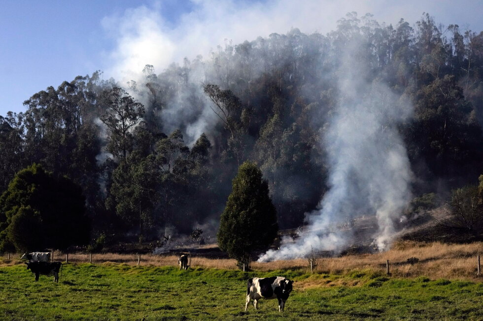
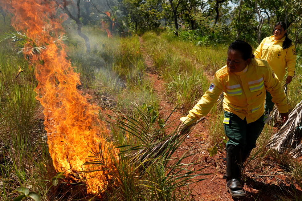
    Beyond economic inequality, unregulated cattle ranching caused severe environmental harm to the island. IBAMA investigations linked grazing activity to soil acidification and increased wildfire risk, as ranchers regularly use controlled burns to clear brush and refresh pasture land. Many of these blazes spread beyond grazing areas, destroying native habitat.

    Bananal Island’s modern conflict has deep historical roots. When European colonizers arrived in the region in the late 18th century, they found the island already inhabited by Indigenous groups and covered in wild banana groves, which gave the island its Portuguese name Ilha do Bananal. The region remained largely undeveloped and overlooked by the Brazilian government until the 1950s, when it was formally designated a protected Indigenous territory. At the same time, federal officials encouraged non-Indigenous ranching through informal leasing arrangements with local communities, setting the stage for the current crisis.

    Three Indigenous groups — the Javae, Karaja and Ava-Canoeiro — currently live on the island. The Javae, in particular, developed long-standing social and economic ties with non-Indigenous ranchers, with many outsiders settling on the island after marrying into local Indigenous communities. These connections allowed ranchers to gain access to develop commercial activity inside the legally protected territory, creating the mixed cultural landscape visible on the island today: modern brick homes stand alongside traditional thatched huts, children play with traditional bows and arrows near Protestant churches, and elderly tribal leaders prepare traditional meals while watching cooking tutorials on YouTube.

    Following the cattle removal, Indigenous leaders on Bananal Island are now rethinking their approach to economic development, working to craft a new model that balances income generation with territorial and environmental protection. The Javae community is partnering with The Nature Conservancy, a global non-profit conservation organization, to develop a comprehensive community-led land management plan that integrates the tribe’s social, economic and environmental priorities.

    In May 2026, Javae leaders traveled to the northern Amazon state of Roraima to study the successful model developed by the Macuxi people, who have become a national example of balancing collective economic development with land rights protection. Starting in the 1980s, the Macuxi developed a community-owned cattle operation to help reclaim their territory from encroachment by farmers, miners and land grabbers, decades before their land was officially demarcated as Indigenous territory in 2005. Today, the Macuxi collectively own more than 45,000 head of cattle, generating sustained shared revenue for the community while protecting their territorial sovereignty.

    The Macuxi and Bananal Island experiences reflect a growing national conversation among Indigenous communities across Brazil about how to balance sustainable economic activity with protection of territorial rights and natural ecosystems, a debate that has also extended to mining. In February 2026, Brazilian Supreme Court Justice Flávio Dino ruled that the Cinta Larga people, whose territory spans the Amazonian states of Mato Grosso and Rondonia, have the legal right to conduct mining operations within their own territory.

    Ivo Aureliano Macuxi, an Indigenous rights advocate and member of the Indigenous Council of Roraima, argues that there is no one-size-fits-all solution for Indigenous economic development. “You can’t apply a single model as a template for other Indigenous lands,” he said, emphasizing that frameworks must be tailored to “each region, each territory, each people.” What works for one community, he added, may not work for another, requiring flexible legal frameworks that respect the self-determination of Brazil’s 391 distinct Indigenous peoples.

    This coverage of climate and environmental issues from the Associated Press receives financial support from multiple private foundations. AP maintains full editorial control over all content.

  • Solar cold storage helps African farmers cut losses and reach global markets

    Solar cold storage helps African farmers cut losses and reach global markets

    On a crisp early morning in Kenya, smallholder farmer Yvonne Anyonyi Mumiah walks between neat rows of aromatic rosemary, fragrant basil and other fresh produce bound for grocery store shelves across Europe. Not long ago, her livelihood hung on a knife edge: a single transport delay or unseasonable heatwave could turn an entire season’s hard work into spoiled, unsellable waste. Today, that uncertainty has been replaced by security, thanks to an accessible solar-powered cold storage service that keeps her harvest fresh until it is ready to ship.

    Mumiah’s new solution comes from SoKo Fresh, a Kenyan cold-chain enterprise that offers a flexible pay-per-use model, billing farmers only for the volume of produce they store. This innovative approach is part of a rapidly growing movement across Africa that leverages renewable energy to solve one of the continent’s most persistent agricultural crises: widespread post-harvest food loss.

    According to estimates from the United Nations Food and Agriculture Organisation, as much as 40% of all food grown across Africa goes to waste between the moment it is harvested and the moment it reaches consumers. The root cause of this crisis is not poor farming practice, but gaping holes in infrastructure: insufficient, inadequate storage, transportation and processing systems that leave perishable goods vulnerable to spoilage.

    Unlike traditional cold storage, off-grid solar-powered cold rooms, cooling hubs and warehouses do not require connection to Africa’s often unreliable and expensive main electricity grids. This model is already gaining traction across multiple sub-Saharan nations, including Kenya, Nigeria, Ethiopia, Rwanda and South Africa.

    For millions of smallholder farmers like Mumiah, purchasing a personal standalone solar cold storage unit – which costs roughly $30,000 upfront – is entirely out of reach. That makes shared pay-per-use models transformative. “You can do everything right on the farm, but if the produce is not stored properly, you lose both the product and income,” Mumiah explained. “We are no longer forced to sell immediately because we fear the produce will spoil. We can wait for collection and still maintain quality.” This flexibility alone has boosted both the quality of her harvest and her overall income.

    As climate change drives rising global temperatures and disrupts supply chains around the world, reliable cooling infrastructure has become more critical than ever. Across major agricultural nations like the United States, China, Japan and the Netherlands, sophisticated, extensive cold-chain networks keep fresh produce marketable for weeks after harvest. But for most of Africa, this essential infrastructure has long been a missing link in the agricultural value chain.

    Rising temperatures have only worsened the crisis: extreme heat speeds up spoilage for perishable goods from leafy greens and fruits to dairy and fresh fish. Meanwhile, inconsistent grid power makes traditional electric or diesel-powered refrigeration prohibitively expensive and impractical for most rural farming communities.

    “Cold storage remains one of the missing links in Africa’s agricultural value chains,” said Emmanuel Aziebor, regional director for Africa at CLASP, a non-profit organisation that supports the deployment of energy-efficient, productivity-driving technologies. “When farmers can store produce for longer, they gain access to better markets, reduce waste and increase incomes.”

    Early data from on-the-ground projects already confirms this impact. SoKo Fresh reports that it has cut average post-harvest spoilage for participating farmers from as high as 50% to less than 2%, while helping producers boost their per-kilogram earnings by up to 50%.

    The model is being adapted to fit local agricultural needs across the continent. In Nigeria, leading firm ColdHubs has installed solar-powered walk-in cold rooms in major agricultural hubs, allowing farmers and local traders to rent space by the day instead of taking on the cost of buying their own equipment. In Rwanda, solar refrigeration supports dairy cooperatives, streamlining milk collection and cutting waste for small-scale dairy farmers. In Ethiopia, cold-chain investments are expanding rapidly to support the country’s fast-growing horticultural export sector.

    Analysts note that these solar-powered innovations deliver two key public benefits at once: they strengthen African food security at a time of growing climate risk, and they cut greenhouse gas emissions compared to traditional cold storage solutions. Most legacy cold storage systems in off-grid areas rely on diesel generators, but solar alternatives eliminate fuel costs, reduce operating expenses, and cut the carbon footprint of agricultural supply chains.

    Yet experts argue that the most transformative impact of these projects is economic, not just environmental. For decades, international development efforts across Africa have prioritized expanding household electricity access, but far less attention has been paid to how that power can be used to generate income for rural communities. “We have neglected the conversation around how people can turn electricity into opportunity,” Aziebor noted. “We keep extending electricity infrastructure, but unless people can use that power productively, the economic benefits never fully materialize.”

    Cold storage is just one of many solar-powered productivity tools transforming African agriculture. Solar-powered irrigation systems now enable year-round farming instead of relying on erratic seasonal rains, while solar milling and processing equipment allow rural communities to add value to their crops close to the farm, cutting transport costs and increasing earnings.

    Despite the clear success of pilot projects, widespread scaling across the continent faces one major barrier: access to affordable funding. “The challenge today is not demonstrating that these systems work,” said Carol Koech, vice president for Africa at the Global Energy Alliance for People and Planet. “It is building enough bankable projects that can attract larger pools of investment and scale across countries.”

    While grants, low-interest loans and donor support can help cover the high upfront capital costs of building new cold storage hubs, industry leaders note that attracting large-scale commercial investment remains challenging. Most African agricultural markets are fragmented, and the sector is dominated by millions of small-scale producers, which many institutional investors see as a high-risk profile. “These investors see emerging technologies as high risk because we lack enough proven business models with reliable returns,” SoKo Fresh CEO Denis Karema said. “That makes funding for our type of projects expensive.”

    This reporting on climate and the environment from The Associated Press is supported by funding from multiple private foundations, and AP maintains full editorial control over all content. Details of AP’s standards for working with philanthropic partners, a full list of supporters, and an overview of funded coverage areas are available at AP.org.

  • Four days of rain slashed population of world’s rarest orangutans, study says

    Four days of rain slashed population of world’s rarest orangutans, study says

    When the Tapanuli orangutan was first formally identified as a distinct species in 2017, conservationists celebrated a rare new discovery in great ape taxonomy. Today, less than a decade later, this newly recognized primate stands on the brink of being lost forever, after a catastrophic extreme weather event wiped out 7% of its entire global population in just four days, new research confirms.

    In late November 2025, Cyclone Senyar tore across the Indonesian island of Sumatra, unleashing four straight days of record-shattering rainfall that triggered catastrophic mudslides and widespread flooding. The storm would go on to become Southeast Asia’s deadliest natural disaster of the year, claiming more than 1,000 human lives. Beyond the human toll, the cyclone inflicted devastating damage on the island’s remaining old-growth Batang Toru forest – the only place on Earth where wild Tapanuli orangutans live.

    In a new study published Wednesday by an international team of primate conservation experts, researchers calculate that at least 58 of the species’ remaining fewer than 800 individuals were killed directly by the storm’s landslides and flooding. Lead study author Erik Meijaard, managing director of Brunei-based conservation NGO Borneo Futures, notes that this updated death toll is a sharp increase from the 35 deaths he estimated just one month after the storm. Meijaard also emphasized that the 58 figure is a conservative estimate, as it does not account for longer-term threats posed by the storm, such as widespread destruction of forest canopy that the apes depend on for shelter and food, and long-term reductions in available fruit sources that will likely lead to additional starvation and population decline.

    In the weeks after the cyclone, humanitarian workers responding to the disaster in central Tapanuli’s Pulo Pakkat village recovered the semi-buried carcass of a Tapanuli orangutan, trapped under mud and fallen timber. Deckey Chandra, a member of the on-the-ground humanitarian team, told the BBC that the site where the orangutan was found had long been a foraging ground for the apes, who came there to feed on wild fruit. “They used to come to this place to eat fruits. But now it seems to have become their graveyard,” Chandra said. Meijaard, who reviewed photos of the recovered remains, described the violent force of the landslides that killed the apes: “If a few hectares of forest comes down in massive landslides, even powerful orangutans are helpless and just get mangled. It must have been hellish in the forest at the time.”

    While Cyclone Senyar was an unprecedented extreme weather event for the region, study authors confirm that human-caused climate change was a major contributing factor to the storm’s formation and intensity. Climate modeling predicts that extreme rainfall events will only grow more frequent and more severe across western Sumatra in the coming decades, creating a persistent, growing threat to the Tapanuli orangutan’s remaining habitat and population.

    Existing population trend research shows that the species will inevitably slide into complete extinction if it loses more than 1% of its total population annually. The 7% loss from a single storm puts the species far above that extinction threshold, making urgent coordinated action critical to save it.

    In a hopeful development, the Indonesian government has implemented a temporary moratorium on large-scale industrial development projects in the protected Batang Toru forest, including planned mining expansions, oil palm plantations, and new hydropower infrastructure. This moratorium has given conservation researchers a critical window to fully assess the ecological threats facing the species and design targeted protection plans.

    The study’s authors emphasize that the catastrophic loss from Cyclone Senyar makes clear just how biologically vulnerable the Tapanuli orangutan is, and that the crisis facing the species is the result of overlapping threats: accelerating climate instability, ongoing biodiversity loss, and chronic underfunding for conservation action. “The crisis facing the Tapanuli orangutan illustrates the convergence of climate instability, biodiversity loss, and vulnerability, calling for a coordinated response matching the scale of the threat,” the study concludes.

    Conservationists argue that preventing the first extinction of a great ape species in modern history is still achievable, but it will require sustained international collaboration, strengthened domestic forest protection policies, climate-responsive conservation planning, and long-term global financial and technical assistance to protect the Batang Toru ecosystem and its remaining primate population.

  • Climate change-fuelled storm decimated world’s rarest great ape: study

    Climate change-fuelled storm decimated world’s rarest great ape: study

    A single extreme weather event amplified by human-caused climate change has delivered a catastrophic blow to the world’s rarest great ape species, new research has confirmed, leaving fewer than 800 Tapanuli orangutans surviving in the wild. According to a study published Wednesday in the peer-reviewed academic journal Current Biology, last November’s Cyclone Senjaya triggered widespread mudslides and flash flooding across Indonesia’s Sumatra island that killed an estimated 58 Tapanuli orangutans. This toll accounts for roughly 7% of the species’ entire remaining wild population, and 11% of the apes that live in the affected Batang Toru Ecosystem – the only protected habitat the species still occupies. The broader flooding event killed more than 1,000 human residents across the region as well.

    Only formally recognized as a distinct species by the scientific community in 2017, Tapanuli orangutans are already one of the most vulnerable large mammals on Earth. The entire wild population is confined to a small, fragmented stretch of highland forest in northern Sumatra, after decades of human development pushed them out of their preferred lowland habitats. Conservation scientists have warned for years that overlapping threats of industrial encroachment and climate-driven extreme weather could push the species to extinction in just a few decades.

    To reach their population loss estimates, researchers from the University of Indonesia and conservation initiative Borneo Futures cross-referenced satellite imagery of landslide damage in Batang Toru with existing maps that track Tapanuli orangutan population density across the ecosystem. Their analysis found that roughly 8,300 hectares of critical forest habitat – more than 11% of the ecosystem’s total forest area – was destroyed or severely damaged by the cyclone-triggered landslides. In addition to the 58 confirmed or projected orangutan deaths, the storm wiped out critical food sources and shelter that the remaining apes depend on for survival.

    “This level of loss is substantial for a species with such a small total population,” explained Erik Meijaard, chief scientist at Borneo Futures. “For a population already on the brink, losing one out of every 14 individuals to a single weather event is a devastating blow that the species cannot absorb repeatedly.”

    Jatna Supriatna, lead researcher from the University of Indonesia, emphasized that the mass mortality event was directly tied to rising global temperatures that have increased the frequency and intensity of extreme tropical cyclones in the region. “The loss of an estimated 58 Tapanuli orangutans to a single climate-induced landslide event is a devastating demographic shock to the world’s rarest great ape,” he said.

    Conservation groups have campaigned for decades to stop planned industrial development in the Batang Toru Ecosystem, including a large proposed hydroelectric dam and ongoing illegal gold mining operations that have already fragmented the apes’ remaining habitat. Data from conservation advocacy group Mighty Earth, released earlier this year, underscores the growing risk: Sumatra lost more than 4.4 million hectares of forest between 2001 and 2024 – an area larger than the entire country of Switzerland – and widespread deforestation has left the island’s hilly landscapes far more vulnerable to catastrophic climate-driven landslides.

    To avoid what would be the first extinction of a great ape species in modern history, Supriatna said, both Indonesian authorities and global stakeholders must take urgent action. “Indonesia must permanently protect the Batang Toru ecosystem from further industrial encroachment,” he said. “But our international partners must also meet their global commitments by providing immediate biodiversity-recovery financing to support habitat restoration and protection efforts.”

  • Colombia passes law to track cattle and keep deforestation-linked beef out of supply chains

    Colombia passes law to track cattle and keep deforestation-linked beef out of supply chains

    BOGOTÁ, COLOMBIA – In a groundbreaking move for global forest conservation, Colombia has signed into law a first-of-its-kind mandatory framework requiring the entire domestic cattle industry to implement full livestock traceability, guaranteeing that national beef supply chains are completely free of deforestation-linked production. Environmental advocates across the globe are hailing the legislation as a historic precedent, marking the first time any tropical forest country has rolled out such a sweeping nationwide rule to curb forest loss driven by cattle ranching.

    Under the new law, government regulatory bodies and private sector actors across the cattle supply chain are mandated to integrate three core systems: individual cattle tracking, official land ownership verification, and real-time deforestation monitoring. This cross-system integration is designed to flag any livestock raised on land cleared of forest, blocking these animals from entering legal commercial supply chains entirely.

    For decades, unregulated expansion of cattle ranching has stood as the single largest driver of deforestation in Colombia’s portion of the Amazon basin, with large swathes of protected forest cleared illegally through land grabbing to create new pasture. Proponents of the legislation argue it will close longstanding regulatory gaps that have allowed cattle reared on illegally deforested land – including grazing areas inside protected national parks and conservation reserves – to launder into legitimate domestic retail and international export markets.

    Susanne Breitkopf, U.S. forest campaigns director for the Environmental Investigation Agency (EIA), an international watchdog that has spent years documenting deforestation tied to Colombia’s cattle sector, emphasized that the law sets a replicable blueprint for other tropical forest nations grappling with the same issue. “This is a win for forests, for Indigenous and local communities that have acted as the world’s most effective forest stewards, and for consumers around the world who are increasingly demanding that the food they buy does not contribute to forest destruction or illicit land activities,” Breitkopf noted.

    The legislation comes at a moment of mounting global pressure, as both governments and agribusiness face growing requirements from international import markets to prove major commodities including beef are not linked to deforestation. Environmental advocates point out that robust traceability systems are quickly becoming a non-negotiable prerequisite for accessing key overseas markets, while also giving law enforcement clearer tools to identify and crack down on illegal land grabbing and forest clearing.

    Data from organizations backing the law shows Colombia has lost roughly 3.3 million hectares (8.2 million acres) of forest in recent decades – an area nearly identical in size to the entire country of Belgium – with the Amazon region seeing the most severe rates of loss. While Brazil’s Amazonian state of Pará has previously implemented cattle traceability rules for producers, environmental groups stress that Colombia’s new law goes further by codifying a uniform, nationwide legal mandate rather than a subnational policy.

    A 2025 EIA analysis underscored the urgency of the reform, finding that hundreds of thousands of cattle were moved between 2020 and 2024 from production areas overlapping protected national parks into legal supply chains. The new law is the culmination of more than five years of coordinated advocacy from environmental organizations, policy researchers, and progressive lawmakers, who have long warned that fragmented oversight and weak regulation allowed illegally deforestation-linked cattle to flow through Colombia’s disjointed cattle supply chain.

    Natalia Katixa Escobar, a researcher with Colombian legal and policy think tank Dejusticia, which has documented the links between cattle expansion and deforestation, explained that the law addresses a long-standing institutional disconnect between Colombia’s agricultural and environmental regulators. “One of its most immediate achievements is that it builds a formal bridge between environmental policy and agricultural oversight,” Escobar said. “For years, the control mechanisms for cattle ranching and traceability had absolutely no integration with environmental monitoring – that gap is what allowed illegal activity to thrive.”

    Colombian Environment Minister Irene Vélez Torres told reporters the new framework will help the government clearly separate responsible, law-abiding cattle producers from actors linked to forest destruction. “This means it will become increasingly hard for forest destruction and illicit economic activity to hide behind the facade of legitimate supply chains,” Vélez said.

    The law sets a phased two-year implementation timeline to give stakeholders time to adapt. Within the first six months, the national government must roll out compliance support programs for small and medium producers, launch an official certification system for deforestation-free beef products, and allocate dedicated funding to strengthen monitoring systems in active deforestation hotspots. After one year, regulators must finalize formal rules for national cattle identification and traceability protocols, and formalize mandatory due diligence requirements for deforestation-free cattle ranching.

    By the end of the second year, all major supply chain actors including slaughterhouses, meat processors, cattle auction houses, traders, and live cattle exporters will be required to have full due diligence policies in place to guarantee their supply chains are deforestation-free. A core component of the reform is the mandatory gradual integration of separate government databases, which for the first time will allow officials to cross-reference data on land tenure, cattle ownership, and recent forest loss to flag illegal operations.

    While supporters say these structural changes will dramatically improve regulators’ ability to intercept deforestation-linked cattle before they reach legal markets, observers warn that the law’s ultimate success hinges on consistent, well-funded enforcement – particularly in remote Amazon regions where illegal deforestation remains rampant and state presence is often limited.

    If implemented fully, the policy could become a global model for other tropical forest countries working to protect their forest ecosystems while retaining access to increasingly sustainability-focused international commodity markets. “The real test will be what happens on the ground,” Escobar emphasized. “While the law fixes critical gaps in oversight and information sharing, reducing deforestation will also depend on improved governance and consistent enforcement in the most remote parts of the Colombian Amazon. Whether it will deliver significant reductions in Amazon deforestation remains to be seen.”

    This coverage from The Associated Press, which received funding from private philanthropic foundations for its climate and environmental reporting, maintains full editorial independence over all content.

  • In Brazil’s Cerrado region, Indigenous fire practices reshape wildfire strategy

    In Brazil’s Cerrado region, Indigenous fire practices reshape wildfire strategy

    On a recent May morning in the remote Xerente Indigenous Territory of Brazil’s northern Tocantins state, a low crackle like distant rainfall drifted across the Cerrado, the sprawling savanna ecosystem that stretches across central and northern Brazil. Unlike the unplanned, destructive blazes that terrorize the region every dry season, these flames were intentional, part of a proactive wildfire prevention strategy forged through a historic collaboration between the Xerente people and Brazil’s federal environmental authorities.

    This year, the work carries extra urgency: with an El Niño event approaching, forecasters warn of prolonged drought and soaring regional temperatures that will create perfect tinder for out-of-control wildfires, amplifying the annual risk the Xerente have faced for generations.

    For decades, the Xerente and other Indigenous communities across Brazil faced systemic prejudice that dismissed their millennia of land management wisdom. Brazilian environmental policy for generations clung to a strict “zero-fire” doctrine, which labeled any controlled burn an illegal threat requiring immediate suppression. But over time, ecological research and shifting policy perspectives have revealed the critical role that low-intensity, controlled fire plays in the natural evolution of savanna ecosystems like the Cerrado. Today, that outdated approach has been replaced by a groundbreaking model: Indigenous ancestral fire management paired with modern scientific monitoring.

    The 2026 controlled burn operation, carried out on May 19, brought together trained Indigenous firefighters and agents from IBAMA, Brazil’s federal environmental protection agency, to map and burn targeted areas of dry vegetation ahead of the August-September peak dry season. On the ground, Xerente firefighters carried on tradition, igniting small, controlled patches with dry palm leaves and drip torches, while a small airborne team dropped precision incendiary spheres from a government helicopter to reach mapped, hard-to-access areas. Crews stood by at all times to immediately extinguish any flames that threatened to spread beyond planned boundaries, leaving behind a patchwork of safely burned plots that will act as natural fire breaks when high-risk season arrives.

    “The Xerente know this region, its climate, its vegetation, and the optimal windows to carry out burns better than anyone,” explained Marco Borges, the IBAMA agent coordinating fire prevention efforts across Tocantins. “We came to learn from their traditional knowledge, adapt it to our conservation goals, and align our work with their relationship to fire. They are our best teachers.”

    Ecologists confirm this approach aligns with the Cerrado’s natural history. “Fire is a natural part of the Cerrado’s ecosystem, and many native species actually rely on periodic low-intensity burns to thrive,” said Leandro Maracahipes, a biologist and researcher at Yale University. Historically, natural blazes sparked by lightning occurred at the start of the rainy season, when fuel loads were low and fires stayed contained. But in recent decades, human activity—particularly clearing for surrounding soy and cattle farms—has shifted fire patterns, leading to far more intense, destructive blazes during the peak drought months of August and September.

    By carrying out controlled burns early in the dry season, when vegetation is not yet fully parched, teams reduce the buildup of excess flammable grass that would otherwise feed catastrophic wildfires. The burned patches form protective barriers around villages, critical headwaters, and ecologically sensitive sites. As Maracahipes explains, the old zero-fire policy backfired dramatically: “Totally excluding fire leads to a massive buildup of fuel that feeds high-intensity burns. These intense fires can kill even the most fire-resilient trees and spread so rapidly across the landscape that firefighting becomes nearly impossible.”

    The day of the operation opened with a traditional ceremony that highlighted the new collaborative dynamic between Indigenous leaders and government officials. When IBAMA convoys arrived at the Xerente territory, 30 Indigenous community members gathered at the people’s association’s wood-and-thatch headquarters, forming two facing parallel lines to create a ceremonial corridor. One line was made up of Xerente firefighters in official bright yellow brigade uniforms, while the other held community members, many shirtless with traditional body paint marking their connection to ancestral land. Together, they chanted traditional songs and stomped in rhythm, welcoming the official team to their territory.

    Waiting at the end of the corridor was 68-year-old Lazaro Xerente, the community’s eldest traditional chief. Clad in a feathered headdress and bearing traditional body paint, he thanked officials for the collaboration but pushed back against the harmful misinformation that often plagues Indigenous communities after major fire events. “People say, ‘Oh, it’s the Indigenous people who are causing fires,’” he said through a translator. “But in reality, since I was born, and long before me, my ancestors have always protected this forest.” After major wildfires, out-of-context images of Indigenous controlled burns frequently circulate on Brazilian social media, falsely blaming communities for destruction that is in fact caused by unregulated clearing activity outside Indigenous territories. All burns in the current program are carefully mapped and monitored by joint fire management teams.

    Planning for each day’s burns combines modern satellite mapping data with generations of Xerente knowledge of the territory’s terrain and ecology, a model that has been formalized through government partnerships dating back to 2014. Some Xerente firefighters are hired on two-year government contracts, receiving formal training and a monthly salary, while others volunteer their time. The program receives partial funding from a partnership between the Bunge Foundation and IBAMA, which supports training and equipment for up to 40 Indigenous fire brigades across five Cerrado and Amazon states.

    This year’s operation is taking place as Brazilian authorities are on high alert for the impacts of the approaching El Niño. The climate phenomenon typically brings hotter, drier conditions to the Cerrado and Amazon, creating ideal conditions for wildfire spread. During the 2023-2024 El Niño event, data from MapBiomas, a nonprofit tracking deforestation and fire activity, shows Brazil suffered historic burning that destroyed more than 30.8 million hectares—an area larger than the entire country of Italy. The Amazon bore the brunt of the damage, accounting for nearly 60% of the total burned area, with the Cerrado ranking second at almost 10 million hectares affected.

    Brazil’s Environment Ministry has been tracking El Niño impacts since the start of 2026 and has deployed more than 4,000 brigade members across the country. Under President Luiz Inácio Lula da Silva, the government established a national fire management policy in 2024 that formalizes cross-sector coordination between authorities, civil society, and Indigenous communities, explicitly including the use of controlled burns led by Indigenous land managers. While the zero-fire policy remains in place for the more moisture-reliant Amazon ecosystem, where extreme drought has made even low-intensity fires a major risk, the Cerrado has embraced controlled burn as a core conservation tool.

    “When applied with technical expertise and traditional knowledge, fire can make a major contribution to environmental conservation,” said André Lima, secretary for deforestation control and land-use planning at Brazil’s Ministry of the Environment. “For example, when used in prescribed burns for sustainable land management, it can help prevent the major catastrophic disasters that destroy vast swathes of ecosystem every year.”

    For the Xerente, the model is a long-overdue validation of the wisdom their ancestors have nurtured for millennia. Bolivar Rodrigues Xerente, a Xerente member working with Brazil’s Indigenous affairs agency FUNAI, summed up the collaborative ethos that underpins the program: “My Indigenous elders taught me that traditional knowledge and modern science are like the two wings of a bird. A bird with two wings can navigate the wind, but with only one wing, it cannot fly. Technology without the traditional knowledge held by Indigenous communities simply does not work.”

  • Sichuan pandas protected by eco-friendly power lines

    Sichuan pandas protected by eco-friendly power lines

    Nestled within the bounds of China’s Giant Panda National Park, the Ya’an region of Sichuan province has emerged as a global stronghold for wild giant pandas, and a groundbreaking infrastructure upgrade is now safeguarding both the endangered animals and their critical habitat. Local power sector officials announced this Wednesday that years of targeted, environmentally conscious modifications to power transmission networks have eliminated once-common threats including wildlife electrocution, habitat fragmentation, and vegetation-triggered wildfires in key panda habitats.

    As one of China’s five pioneering national parks, Giant Panda National Park spans vast swathes of southwestern China, with the Ya’an section covering 5,936 square kilometers — 27 percent of the protected area’s total size. This region is uniquely important to giant panda conservation: it is home to 340 wild giant pandas, boasting the highest population density of the vulnerable species anywhere on the planet. For decades, aging overhead power lines posed hidden risks to both wildlife and the ecosystem: uninsulated lines could electrocute wandering animals, while encroaching bamboo and tree growth near lines raised persistent wildfire risks that threatened both panda habitats and local communities.

    To address these hazards, the Ya’an branch of State Grid Sichuan Electric Power Co has led a systematic retrofitting project focused on balancing human energy needs with wildlife protection. To date, the utility has completed upgrades on three separate 10-kilovolt power lines stretching a combined total of nearly 2.8 kilometers across core protected zones within the park. Beyond adding protective insulation to eliminate electrocution risks, the project has also integrated cutting-edge intelligent monitoring infrastructure along all upgraded routes. These connected systems allow grid workers to track potential hazards in real time, from vegetation overgrowth to equipment faults, ensuring consistent, reliable power access for local residents and economic development while minimizing human disturbance to the fragile panda ecosystem. Since the completion of the first phase of upgrades, no safety or environmental incidents linked to the power infrastructure have been recorded, marking a major success for coexistence between energy infrastructure and biodiversity conservation.

  • Mangrove forests are healing after decades of human destruction

    Mangrove forests are healing after decades of human destruction

    Long known as one of the planet’s most underappreciated environmental workhorses, coastal mangrove forests are now making a surprising global recovery, according to new research published by an international team of scientists. For nearly half a century, these salt-tolerant swampy trees faced rapid, widespread clearing as coastal development, industrial aquaculture, and agricultural expansion pushed human activity deeper into tropical and subtropical shorelines. But the latest study reveals a striking reversal of this decades-long trend: since 2010, global mangrove coverage has grown at a faster rate than it has declined.

    Mangroves deliver a rare stack of interconnected ecological and community benefits that few other ecosystems can match. Their dense, tangled root systems act as natural coastal barriers, dissipating wave energy from storm surges and tsunamis to shield millions of people living in low-lying coastal communities. They are also unparalleled carbon sinks, storing up to five times more carbon dioxide per hectare than most terrestrial forests, making them a critical natural tool in the fight against anthropogenic climate change. Beyond climate and protection, their root networks form thriving nurseries for hundreds of species of fish, crustaceans, and other marine life, supporting global fisheries and coastal biodiversity.

    From the 1980s through 2010, this vital ecosystem suffered devastating losses: more than 12,000 square kilometers of mangrove forest—an area roughly equal to the entire island nation of Jamaica—was cleared across Asia, Africa, and the Americas. Today, that net loss has shrunk dramatically to just 849 square kilometers total since the 1980s, a staggering reduction that points to widespread, meaningful change in how communities and governments value these forests.

    Researchers attribute this shift to multiple interconnected factors, starting with shifting public and policy attitudes spurred by high-profile climate disasters. The 2004 Indian Ocean tsunami, which killed hundreds of thousands of people across the region, was a turning point: communities observed that shorelines protected by intact mangrove forests suffered far less damage and loss of life than those where forests had been cleared. In Indonesia, one of the world’s most mangrove-dense nations, this awareness led to a sharp slowdown in clearing mangroves for commercial fish farms. A similar shift followed Cyclone Nargis in Myanmar in 2008, reinforced by a national logging ban implemented in 2016; today, mangrove coverage is growing steadily there, while it has stabilized in Indonesia after decades of decline.

    Beyond policy and awareness, researchers highlight mangroves’ extraordinary natural resilience as a key driver of recovery. Once human clearing activity stops, these forests can regenerate naturally and expand on their own far faster than many restoration projects can achieve. Improved satellite imaging technology also played a role in documenting this recovery: the study used high-resolution Landsat satellite data, which is far more sensitive to small changes in forest canopy coverage than older mapping systems, allowing scientists to detect new growth that previous global assessments missed. Independent experts note this new data marks a major advance in global mangrove monitoring.

    Even with this encouraging trend, the research warns of remaining threats and uneven progress across regions. West and Central Africa have emerged as new hotspots of mangrove destruction, with the Niger Delta standing out as a particularly hard-hit area. Oil exploration and pipeline construction have left clear, permanent cut through large swathes of the delta’s mangroves, with ongoing pollution degrading remaining stands. Additionally, some new mangrove growth has a hidden environmental cost: in regions like Brazil, increased nutrient runoff from upstream deforestation and mining has created fertile growing conditions for downstream mangroves, meaning one ecosystem’s loss is fueling another’s gain. Intense tropical cyclones also continue to cause large, sudden annual losses from Australia to the Caribbean, threatening long-term recovery in storm-prone regions.

    Despite these caveats, the study’s authors frame the overall trend as a clear win for conservation. Not only has net loss slowed to a near standstill, but existing mangrove forests are also growing healthier: the proportion of closed-canopy mangroves—the most carbon-dense and biodiverse form of the ecosystem—has increased by nearly 20% since the 1980s. Lead researcher Dr. Zhen Zhang of Tulane University emphasized that the global trajectory is clearly moving in the right direction, proving that intentional conservation policy and increased public awareness can reverse even decades of ecosystem decline.

  • Australian environment groups write to UN over fears for Great Barrier Reef

    Australian environment groups write to UN over fears for Great Barrier Reef

    As the United Nations prepares to convene a critical global meeting on the future of one of Australia’s most cherished natural landmarks, five of the nation’s largest environmental advocacy organizations have issued an urgent formal appeal to the world body to place Great Barrier Reef land clearing practices under ongoing annual international oversight.

    Drafted in April and signed by the Australian Climate and Biodiversity Foundation, Greenpeace Australia, the Australian Conservation Foundation, WWF Australia, and the Wilderness Society, the open letter calls on UNESCO to mandate annual progress reports from the Australian federal government through 2030, requiring verifiable evidence that rates of harmful land clearing in reef catchment areas are steadily declining.

    Stretching more than 2,300 kilometers along Australia’s northeast coast, the Great Barrier Reef was inscribed on UNESCO’s World Heritage List in 1981. It contributes more than AUD $9 billion annually to the national economy and supports tens of thousands of jobs, cementing its status as both an ecological and economic cornerstone of the country. In recent decades, however, UNESCO has labeled the reef a site of “utmost concern” amid mounting threats from climate change, rising ocean temperatures, and declining water quality driven by upstream human activity.

    Of all the hazards facing the reef ecosystem, unregulated land clearing in the river catchments that drain into the Coral Sea is ranked among the most damaging. Environmental advocates warn that large-scale deforestation loosens dry sediment and allows toxic agricultural pesticides to wash downstream directly onto reef systems, where sediment smothers living coral and blocks the sunlight coral needs to survive. In response to growing pressure, the federal Albanese government passed landmark reforms to the Environment Protection and Biodiversity Act late last year, introducing mandatory federal environmental assessments for all new land clearing projects within 50 meters of waterways that flow into the reef catchment.

    While the letter acknowledges that the new reforms represent a promising first step toward addressing runoff and poor water quality, the groups warn that implementation could range from highly effective to completely inadequate to address the concerns UNESCO first flagged in 2025. The advocacy groups emphasize that securing strong, consistent enforcement of the updated national environment laws would offer a once-in-a-generation opportunity to reverse decades of damage to water quality caused by large-scale deforestation in upstream catchments.

    The letter outlines that it will take between 12 and 36 months to accurately assess whether the reforms are successfully protecting high-value native vegetation and cutting harmful runoff that impacts the reef’s World Heritage-listed values. Several key gaps remain in the regulatory framework that have delayed meaningful oversight, the groups note: Queensland’s state government retains primary regulatory authority over most land clearing in reef catchments, and it remains unclear whether the state will fully cooperate with the new national rules or strengthen its own existing regulations. Additionally, the national environmental standards that will guide land clearing assessment decisions have not yet been finalized, there is no comprehensive public data on ongoing clearing activity, and no formal compliance mechanisms to enforce reporting requirements—current rules rely entirely on voluntary self-referral by landholders. The new federal National Environmental Protection Agency, tasked with enforcing the reforms, will not launch until at least July 2026, leaving a years-long gap in formal regulatory oversight.

    New details of regulatory gaps emerged last week during Senate estimates hearings, where it was revealed that out of 248 calls and 11 emails from landholders seeking clarification on land clearing rules from the Department of Climate Change, Energy, the Environment and Water (DCCEEW), only six landholders received a formal pre-referral consultation meeting. Department officials confirmed they expect only two or three of these inquiries to progress to full formal assessment, and they have yet to confirm how many of the requests relate specifically to projects within the Great Barrier Reef catchment. During questioning, Declan O’Connor-Cox, head of Queensland’s Environment Assessments branch, clarified that exemptions for ongoing continuous clearing do not apply to projects within 50 meters of reef catchment waterways: even if a property cleared the same stretch of land two years ago, any new clearing requires fresh assessment under the new rules.

    Lyndon Schneiders, executive director of the Australian Climate and Biodiversity Foundation, emphasized that the reef is a defining Australian icon that requires urgent government action to protect. “The time is now for Environment Minister Murray Watt to lead and put in place strong protections to ensure the clearing stops and the reef is given a helping hand,” Schneiders said. “As a Queenslander, he knows the reef is special, and as a former agriculture minister, he also knows that sometimes a small number of cowboy beef farmers make the whole industry look bad. It is in everyone’s interest to stop the clearing and help the Reef.”

    The appeal comes less than two months before the UNESCO World Heritage Committee convenes its annual meeting on July 19, where the future of the Great Barrier Reef and Australia’s management of the site will be a core item on the meeting’s agenda.

  • Venice’s growing flamingo population finds refuge in recovering wetlands

    Venice’s growing flamingo population finds refuge in recovering wetlands

    VENICE, Italy — For generations, the iconic pale pink flamingo has been absent from local Venetian vocabulary, a quiet reflection of how recently these striking birds have made the Venetian Lagoon their home. Today, that narrative is shifting dramatically: flamingo numbers in this storied coastal ecosystem have hit all-time highs, as large-scale wetland restoration projects create new viable habitats that could soon support the first permanent, self-sustaining nesting colony in the region’s modern history.

    Flamingos, which have long established major nesting sites in Spain and France, first began appearing in the 550-square-kilometer Venetian Lagoon in the early 2000s. Initially, sightings were largely limited to remote fishing valleys and tidal mudflats along the lagoon’s outer edges, with almost no encounters in the canal-laced historic center that draws millions of global tourists each year. That pattern has shifted sharply in recent years, however. Last year’s official ornithological census counted nearly 24,000 wintering flamingos in the lagoon — an increase of 8,000 from the previous year’s total.

    “This count cements the Venetian Lagoon as one of the most critical wintering grounds for flamingos across their entire European range,” explained Alessandro Sartori, a leading ornithologist who monitors the lagoon’s bird populations weekly by boat. Over 90% of the counted flamingos currently congregate in the northern lagoon, where large expanses of intact natural salt marsh and semi-natural traditional fishing valleys provide abundant food sources. These managed embanked wetlands, however, have also created occasional conflict between the feeding birds and local fishing activity.

    Sartori has spent years searching for signs of successful nesting, a milestone that would confirm the establishment of a self-sustaining local colony. Two previous attempts in 2008 and 2013, in northern lagoon fishing valleys, ended in devastating setbacks: a severe hailstorm killed dozens of young birds, halting early colonization efforts. That could change soon, thanks to a landmark EU-backed wetland restoration project focused on rebuilding eroding salt marshes in the isolated southern lagoon, located beyond Venice’s historic center and the Marghera industrial port.

    Once, nearly half of the entire Venetian Lagoon consisted of natural salt marshes, known locally as *barene* in the Venetian dialect. Today, salt marshes make up just 7% of the lagoon’s total area, with only half of that remaining habitat naturally formed. Decades of erosion, accelerated by the dredging of shipping channels for the Marghera industrial port in the 1960s, has pushed the lagoon toward a worrying transition: without intervention, it could eventually degrade into an open marine bay, according to conservation leaders.

    The 23.6 million euro ($27.5 million) five-year WaterLANDS project, led in part by local conservation group We Are Here Venice, aims to reverse that trend by rebuilding salt marsh habitats at a scalable scale. Beyond creating new feeding and potential nesting grounds for flamingos, restored salt marshes deliver major climate benefits: they trap carbon dioxide, the primary greenhouse gas driving climate change, and buffer the lagoon against the impacts of rising sea levels. “This project is designed to prove that we can reverse centuries of erosion and change the trajectory of the lagoon,” said Jane da Mosto, executive director of We Are Here Venice.

    Conservation teams working on the southern lagoon project have already documented clear signs of increasing flamingo activity, from scattered pink feathers to regularly feeding flocks. Sartori has already observed a dramatic jump in flamingo numbers in the restored southern wetlands: over the past three years, counts have grown from just a handful of birds to between 300 and 400 during peak wintering periods. “Our hope is that just as flamingos have established nesting colonies in other parts of the Mediterranean, they will find suitable breeding ground right here on these restored barene,” Sartori said.

    Beyond conservation gains, the arrival of Venice’s pink newcomers offers a new opportunity to reframe the city’s ecological identity, adding a layer of natural significance to its already well-known historical and cultural heritage. While casual flamingo sightings remain rare for most tourists — the birds favor remote, shallow tidal reaches that require careful navigation through shifting channels, and they scatter quickly when disturbed by human activity — Sartori predicts that flamingo watching will become an increasingly popular sustainable activity as populations grow, with occasional sightings already possible from the shores of the popular lagoon islands of Murano and Burano. He emphasized that any wildlife viewing must prioritize the birds’ safety, with visitors maintaining a safe distance to avoid disrupting their feeding and resting routines.

    The Associated Press’ climate and environmental reporting is supported by funding from private philanthropic foundations, with AP maintaining full editorial control over all content.