A catastrophic glacial collapse in the transboundary Nepal-Tibet region has unleashed a deadly flash flood along Nepal’s Trishuli River, leaving hundreds dead and hundreds more unaccounted for, new satellite and on-the-ground imagery has confirmed. The disaster, which struck on a Wednesday, has carved a 45-kilometer trail of destruction through river valleys, wiping entire villages, critical infrastructure and agricultural land off the map.
New before-and-after satellite analysis from two leading private space firms has laid bare the full scope of the devastation, which stretched from the glacial collapse site at the border all the way downstream to lowland Nepalese communities. Verified drone footage captured the exact moment a massive ice chunk broke free from the glacier, leaving a jagged, debris-strewn scar across the mountainside. Planet Labs imagery shows that vegetation and trees were stripped clean from the rock face up to 300 meters above the original riverbed, highlighting the sheer force of the ice and subsequent flood surge.
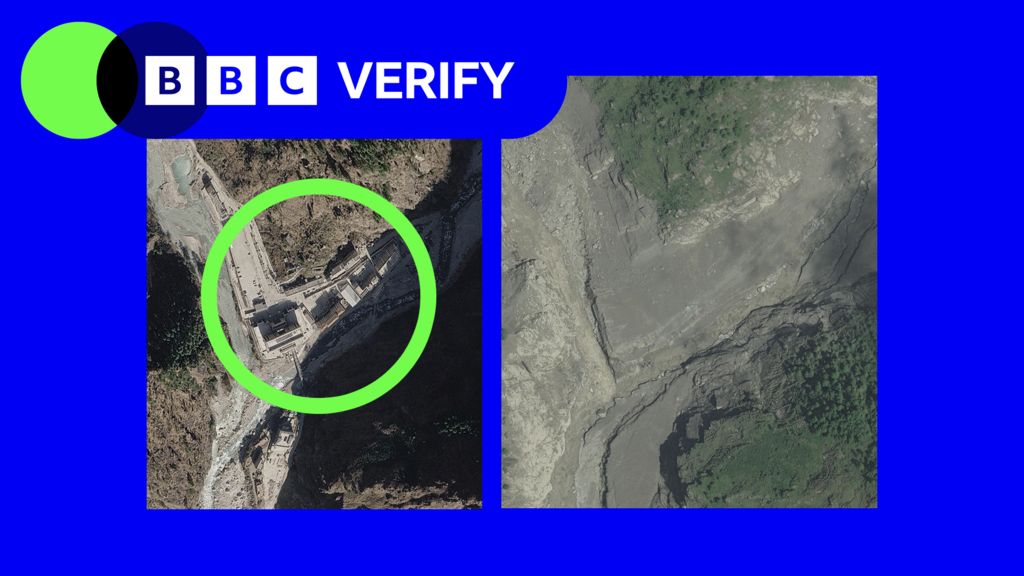
The destructive floodwaters carved a path west from the collapse site before turning south along the Trishuli, leaving widespread ruin in every community in its path. At the Nepal-Tibet border crossing, one of the disaster’s hardest-hit locations, imagery from U.S.-based intelligence firm Vantor — released through the company’s open disaster data program — shows the crossing has been almost completely washed away by the rushing water. Shocking CCTV footage from the site captures the moment the churning, debris-laden deluge overwhelms border structures as people scramble to escape to higher ground.
Visible damage extends more than 2.5 kilometers upstream from the border, with floodwaters and mud reaching 100 meters above the original impact zone. Just a few miles south of the crossing, the small mountain village of Timure has largely vanished from satellite views. Most homes perched along the valley’s steep 50-meter slopes have been either swept away entirely or buried under thick layers of mud and rock. Ten kilometers further downstream in Syapru Besi, the entire settlement is now blanketed by debris, with homes, bridges and a major hydroelectric power plant all destroyed by the surge.
Further downstream, 45 kilometers from the original collapse site, lies the larger town of Trishuli, which bore the full force of the flood. Verified on-the-ground footage from Trishuli captured dramatic scenes of chaos and destruction: a major road bridge crumples and collapses into the surging river, while passengers trapped on a passing bus scream and scramble for safety as floodwaters rush past. Other videos show survivors huddling on a residential balcony, watching helplessly as the torrent carries large metal debris and a full-sized vehicle toward their home — which, miraculously, remained standing through the disaster. After the waters receded, survivors can be seen emerging from the intact structure to survey a landscape completely covered in thick mud.
In the wake of the initial collapse, a barrier lake formed at the base of the landslide above the flood path, creating a new secondary hazard that has complicated ongoing rescue and recovery efforts. Chinese authorities have warned that the unstable natural dam poses a major risk of a second catastrophic flood if it fails. Glaciologist Dr. Argha Banerjee, of the Indian Institute of Science Education and Research, told BBC Verify that current satellite imagery is not sufficient to confirm the barrier’s long-term stability or the risk of sudden drainage. However, he noted that the lake’s surface area did not expand significantly between the first two days after the disaster, even as water continued to flow into the basin. A visible natural drainage channel is already allowing some water to escape downstream, and the lake’s current volume is “not alarmingly large” and appears to have stabilized, Banerjee added.
As of the latest update, Nepalese officials have confirmed more than 550 fatalities, with hundreds of people still reported missing. The extent of damage on the Tibetan side of the border remains unclear, due to strict media access restrictions in the region. BBC Verify has not yet been able to obtain independently verifiable footage or casualty data from the Tibetan side of the border. The open-source satellite imagery released by Vantor is intended to help disaster response authorities prioritize search, rescue and recovery operations, by providing clear geospatial data on the locations of the most severe damage.