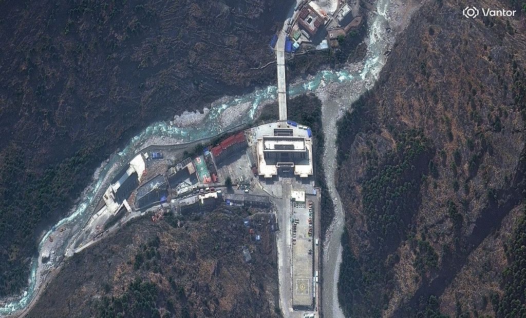
On August 26, a catastrophic glacial outburst flood tore through the high-altitude border region between Nepal and China, wiping out infrastructure, destroying the iconic cross-border Friendship Bridge, and leaving hundreds of people unaccounted for in one of the deadliest natural disasters to hit the Himalayas in recent years. Visual evidence captured through pre- and post-disaster satellite imagery and local CCTV footage has begun to reveal the full scale of the destruction that unfolded in mere minutes.
A few seconds of chilling CCTV footage from Gyirong, the Chinese side of the border crossing, captures the moment disaster struck: what first resembles a dark, foreboding cloud sweeping over the ridgeline behind border buildings rapidly resolves into a churning mass of water, mud, ice, boulders, and rock surging down the valley at deadly speed. The footage is timestamped 10:59:53 local Tibet time, just seven minutes after a glacial collapse triggered the torrent high in the mountains, per Chinese disaster assessments, and less than 10 minutes after Nepal’s immigration system logged its final transaction at the Rasuwagadhi crossing.
In the wake of the surge, large swathes of the border’s built infrastructure simply vanished. Most of the Gyirong border complex was swept clean off the valley floor, while across the international frontier in Nepal’s Rasuwa district, the destruction was equally severe. The Friendship Bridge, the decades-old structural link between the two nations, was torn from its foundations and washed away, alongside Nepal’s entire immigration and customs compound. Timure, the small mountain trading settlement that had grown up around the busy crossing, was left in ruins.
Geographically, this key trans-Himalayan route has long been recognized as a high-risk zone. Ajay Dixit, a leading Kathmandu-based hydrologist, explains that the corridor is a historic travel link between Kathmandu and the Tibet Autonomous Region of China, defined by steep gorges, fast-flowing sediment-heavy rivers prone to carrying massive debris downstream, and inherent geological instability that makes flash floods a persistent threat. Today, the crossing remains a vital economic and cultural gateway, traversed daily by Mount Kailash pilgrims, cross-border traders, truck drivers, customs officials, tourists, and local border communities.
In the hours before the flood hit, the crossing was unusually busy. Electronic immigration records from Nepal confirm that 89 foreign and Nepali nationals had cleared exit checks to enter Tibet, while four people had registered for entry into Nepal. That count, however, only captures a fraction of the people present in the border zone. Tika Ram Pokharel, a senior immigration assistant at Rasuwagadhi who was the only office staff member to survive—he had traveled to Kathmandu to take a mandatory work exam that morning—told reporters that between 300 and 400 people were waiting to cross into Tibet, with additional travelers from the Chinese side also in the area.
The full extent of the human toll remains uncertain, weeks after the disaster. India’s foreign ministry confirms that at least 275 Indian nationals are missing across Nepal, with more than 100 of those unaccounted for believed to have been at the Rasuwagadhi crossing when the flood hit. Among the missing are 32 Indian nationals who cleared Nepali exit checks that morning, as well as 77 pilgrims with the Isha Foundation returning from Mount Kailash who were at the Chinese border facility. Four senior Nepali immigration staff, including the head of the Rasuwagadhi office, are also missing; his body was recovered days later far downstream, while the female officer who logged the final immigration transactions remains unaccounted for. Pokharel, who lost 40 to 50 close friends in the disaster, estimates the actual death toll could be far higher than official counts, suggesting between 2,000 and 2,500 people may have been caught in the surge—an estimate that has not been independently verified.
The geologic timeline of the disaster has left many questions about why so many people were trapped. Seismic sensors detected glacial movement above the border just two minutes after the final immigration transaction was logged, at 8:37 a.m. Nepal local time. Researchers confirmed the seismic shift marked the collapse of a section of mountain glacier that triggered the outburst flood. Once travelers cleared Nepali immigration, it took 15 to 20 minutes to walk the 3.5-kilometer stretch from the immigration office at Ghatte Khola Bazar to the Friendship Bridge, meaning most of the 89 people who cleared exit checks that morning would still have been en route when the flood hit. Ghatte Khola itself, which was home to 50 to 60 local houses, hotels, shops, four hydropower facilities, and a bus terminal for Kathmandu-bound travelers, was completely submerged, with floodwaters surging higher than the 100-meter elevation of the immigration office itself.
Personal accounts from families of the missing underscore the suddenness of the disaster. For many pilgrims, the morning began as a routine wait to cross the border. Sudipto Bhattacharya received final updates from his wife Subhrasree Chakraborty, who was traveling with a group of 60 pilgrims: at 7:57 a.m., she sent a photo of her exit stamp, confirming Nepali immigration was complete. At 8:03 a.m., she sent one last message: “We are waiting to enter China.” Communications cut out moments later, and she has not been heard from since.
When Chinese rescue teams reached the devastated Gyirong border area on August 28, they found a landscape of total destruction. “As far as the eye could see, there was nothing but ruins,” one rescuer told Reuters. The disaster comes just 18 months after a separate major flood shut the crossing for nearly six months, which only reopened on January 1 after Chinese engineers constructed a temporary replacement bridge. By June of this year, cross-border traffic had returned to pre-flood levels, with Chinese authorities recording more than 100,000 crossings through Gyirong in the first half of 2026, and Nepali immigration recording 53,742 total arrivals and departures in the 12 months to mid-July.
Beyond the human cost, the disaster has major economic implications for Nepal, which relies heavily on the Rasuwagadhi crossing for trade with China. Posh Kumar Pandey, chairman emeritus of the Kathmandu-based South Asia Watch on Trade, Economics and Environment, notes that Rasuwagadhi is one of Nepal’s only two major land trade ports with China, accounting for roughly one-third of Nepal’s total $2.95 billion in annual trade with its northern neighbor. Up to 70 cargo trucks crossed the border daily, carrying Chinese electronics, machinery, vehicles, clothing, and fruit into Nepal, and the route handles an estimated 80% of all of Nepal’s electric vehicle imports from China.
With both Rasuwagadhi destroyed and Nepal’s second major trade crossing at Tatopani temporarily closed by Chinese authorities due to ongoing landslide risks, Nepal is currently left with no active major land trade routes with China. Pandey warns that the disaster exposes the risks of Nepal’s overreliance on a small number of high-risk border corridors. “We have put all eggs here,” he said. “We need to develop an alternative border port.” He added that Nepal should also reconsider its strategy of concentrating dozens of hydropower projects along the same geologically unstable river system.
For the few survivors like Pokharel, the disaster carries a deeply personal weight. He recalled that after the 2025 flood, his colleagues were acutely aware of the ongoing flood risk, often checking the river at night after feeling seismic vibrations and discussing emergency escape routes uphill if another flood struck. “But my friends could not get that chance,” he said. Search and rescue operations are still ongoing in the region, with Chinese helicopters delivering emergency supplies to cut-off areas and recovery teams working to locate missing persons amid the mud and debris.