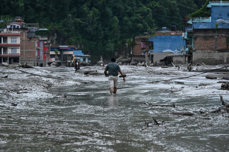
On Wednesday morning, a catastrophic disaster of flash floods and landslides struck the Nepal-Tibet border region, leaving at least 160 people dead and hundreds unaccounted for, as experts work to untangle the causes of the event and unpack what it signals about growing hazard risks in the Himalayan highlands.
Footage captured from the Chinese side of the border captures the devastating force of the surge: a towering, churning wall of mud and debris slammed into a multi-story building, swallowing the structure whole and sweeping away buses and private vehicles as if they were lightweight children’s toys. In Nepal’s Nuwakot district, residents have been forced to navigate streets coated in thick, clinging mud in the disaster’s aftermath.
Initial reports suggested a 4.4-magnitude earthquake had triggered a landslide that blocked a mountain river, with the flood unleashed when the natural dam eventually burst. That account was put forward by Nepal’s Foreign Minister Shishir Khanal, but new analysis from the United States Geological Survey (USGS) has revised that narrative. USGS experts found that the seismic activity initially recorded was not caused by an earthquake, but rather by the massive movement of the landslide itself.
Preliminary findings from the International Centre for Integrated Mountain Development (ICIMOD), an intergovernmental organization based in Kathmandu, have ruled out any unusual activity originating on the Chinese side of the border. According to Sarthak Shrestha, a remote sensing and geo-information analyst at ICIMOD, the most likely sequence is that a rock-ice avalanche occurred on Nepal’s side of the border, which blocked the Lhende River and set off the cascading flood that swept through downstream communities.
One of the most alarming details experts have highlighted is that the disaster struck with almost no warning. Hatim Sharif, a hydrologist at the University of Texas San Antonio, noted that there was no heavy rainfall in the region ahead of the flood — a detail that renders most operational global early warning systems useless for this type of event.
By the time a fast-moving mud surge like this is visible to people in its path, it is already too late to escape by running or even by car, Sharif explained. The mixture of water and rock debris moves at high speed and becomes dense enough to act like “liquid concrete,” making escape along flat ground impossible. Sharif’s guidance is that the only chance of survival is to immediately climb to high ground of at least six meters (20 feet) above the river level.
Looking ahead, Sharif said that one viable long-term adaptation is to install real-time river level monitoring gauges across high-risk Himalayan river systems. While this would not prevent the disaster, it could give vulnerable communities 20 to 30 minutes of advance warning to evacuate to safe ground.
Dorothy Heinrich, a climate and hazard researcher at the University of Reading in the United Kingdom, explained the unique geographic factors that make these blockage-induced floods so dangerous in mountain regions. “In these mountain environments, the rivers can be quite narrow in areas,” she noted. When any kind of landslide or avalanche blocks a narrow river channel, water rapidly accumulates behind the natural obstruction, and the eventual breach releases an incredibly fast, powerful surge downstream.
ICIMOD head of climate and environmental risks Qianggong Zhang has warned that the risk is not yet over: an upstream blockage remains in place, raising the possibility of a second destructive flood in the coming days.
While it is too early to draw a direct, definitive link between this disaster and human-caused climate change, scientists say well-documented environmental shifts across the Himalayas — often called the “Roof of the World” — have already increased the likelihood of similar events. Nepal is particularly vulnerable to glacial lake outburst floods (GLOFs), catastrophic events that occur when glacial melt leads to a sudden breach of a natural glacial lake dam, releasing billions of liters of water downstream. A major GLOF event originating in China’s Gyirong County hit Nepal’s Rasuwa District just last July, though investigators have not yet confirmed a GLOF caused the latest disaster.
In the coming weeks, climate scientists around the world will conduct event attribution studies to examine what role climate change may have played, comparing the probability of such an event occurring in today’s fossil fuel-warmed climate versus the climate of the pre-industrial era. Heinrich noted that researchers already have high confidence that climate change is driving major shifts across the Himalayas: rising temperatures, more frequent heatwaves, widespread glacial retreat, and permafrost thaw, all of which increase the frequency and severity of landslides, avalanches, and outburst floods. Still, she emphasized that a definitive connection to this specific disaster can only be confirmed through formal attribution analysis.