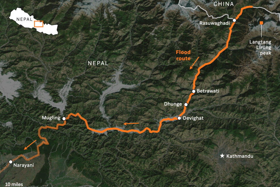
In the wake of catastrophic flash flooding that ripped through mountain valleys along the Nepal-China border Wednesday, rescue crews continued a grim search for dozens of missing people Thursday, while a team of international earth scientists used satellite imagery to unpack the sequence of events that triggered the disaster. The flooding has already claimed hundreds of lives across Nepal and the Tibet Autonomous Region of China, with scores of unaccounted people still unaccounted for, including foreign travelers and religious pilgrims visiting the region’s sacred high-altitude sites.
Initial analysis of Wednesday’s satellite imagery was hampered by heavy cloud cover and dust kicked up by tons of falling debris and ice, but clearer scans taken Thursday allowed geomorphologists Kristen Cook of France’s Université Grenoble Alpes and Dan Shugar, an associate professor at the University of Calgary, to piece together the full scope of the geologic failure. Early observations had only confirmed that a large section of glacier had broken away from Langtang Lirung, a 7,234-meter peak that sits just kilometers from the international border. But the sharper Thursday images revealed that the collapse extended far deeper than the glacial ice: the entire underlying bedrock of the mountainside had fractured and slid into the steep valley below, carrying the massive glacial ice chunk, thousands of tons of boulders, and loose sediment with it.
“It shows the whole area without anything hidden, and we could see that, yes, it looked like there was not only this glacier that had failed, but a much larger chunk of the bedrock of the mountainside itself that had given way,” Shugar explained. “You have this big bedrock failure that took part of the glacier with it.” Describing the downstream view captured in the imagery, Shugar called the scene of entire villages buried under meters of debris “heart-wrenching.”
Cook explained that after the collapse slammed into the valley floor, momentum carried the massive debris flow down the steep, narrow gorge, even as the fallen glacial ice began to melt rapidly. The mixture of meltwater, mud, rock, and ice grew to heights equal to several multi-story buildings before it swept through settled communities along the river banks.
Before-and-after satellite comparisons of the affected river systems paint a stark picture of the flood’s destructive power. Nepal’s Trishuli River, a major waterway in the region, is now far wider than its pre-flood course, with water that has shifted from its usual greenish hue to a dark, muddy brown—a visible marker of the massive volume of sediment the flood dragged downstream. Entire riverbank towns and villages now lie submerged under thick layers of debris, appearing as uniform brown expanses in imagery, with only the roofs of a handful of partially buried houses visible in the Betrawati area. Syapru Besi, a popular tourist hub and the main starting point for treks into the Langtang Valley, saw all riverside buildings toppled and swept away; the force of the debris flow was so powerful that it pushed a side tributary off its original course, widening its channel permanently.
Alton Byers, a mountain geographer at the University of Colorado Boulder’s Institute of Arctic and Alpine Research who has studied glacial hazards in Nepal for decades and visits the country annually to work with local communities on disaster preparedness, called this event the most destructive glacial flood he has ever observed. He noted the destruction has left a barren wasteland in the disaster zone that will require decades to recover.
Byers also linked the disaster directly to human-caused climate change, arguing that rising global temperatures are thawing high-altitude permafrost that has held mountain rock, soil, and ice together for thousands of years. As permafrost weakens, it leaves steep mountainsides unstable, increasing the risk of large collapses that can trigger cascading hazards like glacial outburst floods and debris flows.
“All the indicators, to me, point to the impacts of warming trends,” Byers said. “In this case, the permafrost that for millennia has helped to hold together high-altitude rock and ice and soil and glaciers is now weakening and becoming unstable.”
Cook and Shugar cautioned that it is too early to confirm a direct causal link between this specific massive collapse and climate change, noting that bedrock failures and landslides are natural geologic processes that have occurred for millennia. Still, both scientists acknowledged that thawing permafrost driven by a warming climate does increase overall slope instability across the Himalaya, and that more large events of this type should be expected as global temperatures continue to rise.
“While we cannot at this point directly link this collapse to climate change, it is not unexpected to see more events of this type with a warming climate,” Cook said. “Not this big, hopefully not this big.”
This reporting from The Associated Press, which receives funding from private foundations for its climate and environmental coverage, is independently edited and produced by AP.