A string of significant seismic events stretching across three continents has put modern earthquake early warning (EEW) systems in the spotlight, demonstrating how mobile technology is buying vulnerable populations critical extra seconds to reach safety when shaking begins.
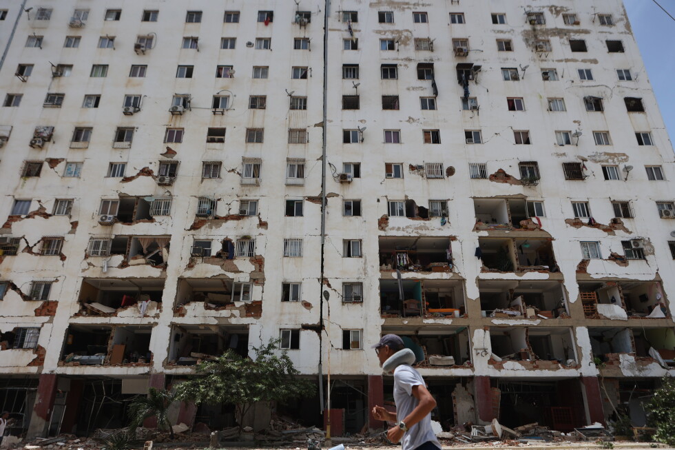
Over a single week in early June, seismic activity triggered alerts for millions of people across North America, South America and Asia. The sequence opened with a moderate quake rocking parts of California, United States, and closed with two powerful back-to-back earthquakes measuring 7.2 and 7.5 magnitude striking northern Venezuela — one of the most intense seismic sequences to hit the South American nation in more than 100 years. The events came just weeks after a magnitude 6.5 quake near Mindanao in the Philippines claimed 37 lives. Even in nations without a national public EEW infrastructure, consumer mobile technology stepped in to deliver advance warnings to at-risk residents.
Today, more than a dozen nations and territories operate formal public EEW programs, according to the U.S. Geological Survey (USGS), including the U.S., Mexico, Japan, Turkey, Romania, China, Italy and Taiwan. While Venezuela does not maintain a national system, many of its Android phone users still received advance warnings of the recent powerful quakes through Google’s crowdsourced Android Earthquake Alerts platform. For 39-year-old Caracas-based writer Pericles Sánchez, that advance notice meant enough time to get his entire family outside to safety before shaking reached his neighborhood. “It wasn’t until we were already outside that we started to feel it,” Sánchez said, adding his family’s home escaped structural damage.
On the U.S. West Coast, the USGS runs a dedicated EEW platform called ShakeAlert for California, Oregon and Washington, which distributes alerts through multiple channels including the state-run MyShake mobile app. When the recent moderate quake hit California, more than 4 million users received advance alerts through the interconnected system, according to USGS scientist Robert de Groot.
Though modern EEW technology is saving lives today, it remains a relatively new innovation that continues to evolve rapidly. The world’s first public EEW launched in Mexico in 1991, and the country now disseminates large quake alerts through broadcast networks, mobile apps and public alarm systems, alongside regular nationwide earthquake response drills to prepare residents. After the 2011 magnitude 9.0 Tohoku earthquake and tsunami that killed more than 22,000 people and triggered the catastrophic Fukushima Daiichi nuclear meltdown, Japan dramatically expanded its EEW infrastructure to include offshore monitoring. Its cutting-edge Seafloor Observation Network for Earthquakes and Tsunamis (S-Net) uses thousands of miles of undersea cables and sensors to monitor activity along the offshore subduction zone where destructive quakes often originate. The system, widely regarded as the most sophisticated in the world, has added an extra 20 seconds of warning time for most quakes and cut tsunami alert delivery times by as much as 20 minutes. California’s MyShake app, launched in 2019, has pushed out 6.8 million alerts for 194 separate seismic events to date, state data shows.
All EEW systems operate on the same core scientific principle: earthquakes generate sequential waves that move at different speeds. Faster, lower-intensity P-waves arrive first, followed by far more dangerous, slower S-waves and finally the most destructive L-waves. Most traditional public systems use a network of ground-based seismometers to detect initial P-waves, rapidly process data to estimate the quake’s location and magnitude, and push alerts to at-risk regions before destructive shaking arrives. Alerts are distributed through multiple channels, including national Wireless Emergency Alert (WEA) systems, dedicated mobile apps and regional public warning networks. Having overlapping distribution channels creates critical redundancy in case one system fails, de Groot explained. “It’s always good to have more than one way of getting alerts. It’s the reason why you carry a spare tire in your car or carry some small bills in your wallet because the ATM may not work,” he said.
Google’s Android system uses a different crowdsourced model that leverages built-in accelerometer sensors already included in every Android device — the same sensors that rotate a phone’s screen when the device is turned. When multiple stationary phones in one region detect P-wave activity, the data is sent to Google’s central processing center, which confirms the seismic event and pushes alerts to nearby users. This model allows EEW coverage to extend to nations that lack the funding or infrastructure to build a traditional national seismometer network.
Because alert signals travel at the speed of light — far faster than seismic waves move through the Earth’s crust — warning time correlates directly with distance from the quake’s epicenter. People closest to the epicenter typically get the shortest warning windows, sometimes only a few seconds or no warning at all before shaking begins, while people further away get more preparation time, almost always less than a minute. The level of detail included in alerts also varies by distribution channel: standard WEAs are limited to 90 characters broadcast directly from cell towers, while app-based alerts from platforms like MyShake or Google often include extra context such as the distance to the epicenter and estimated magnitude. All official alerts, regardless of format, include the universal safety instruction to “drop, cover, hold on.”
This reporting was compiled from contributions by journalists across the U.S. and Mexico, with on-the-ground sourcing from Venezuela and California.