On Monday morning, a 7.8-magnitude earthquake — one of the most powerful seismic events to strike the Philippines in 50 years — hit off the coast of Mindanao, the nation’s second most populous island. As of Tuesday, official tallies confirm at least 37 people have been killed, nearly 500 injured, and more than 20,000 displaced by the disaster, with only four people still listed as missing.
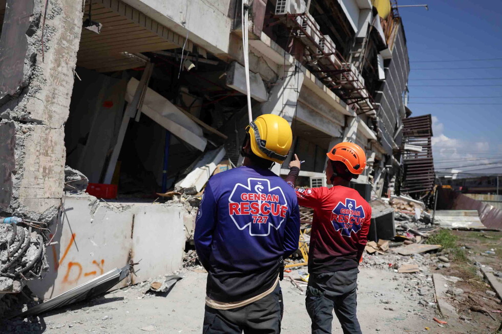
By Tuesday, rescue teams had shifted to a methodical search of collapsed and severely damaged structures across southern affected provinces, working to locate any possible trapped survivors or unaccounted casualties. Rafaelito Alejandro, spokesperson for the Philippine Office of Civil Defense, emphasized that even structures that appear partially intact require full inspection to account for anyone who may have been caught in the collapse.
Most of the casualties are concentrated across four southern regions. In General Santos, a bustling coastal city of 700,000 known nationally as the Philippines’ tuna capital, at least 13 lives were lost to falling debris and building collapses. Sarangani province recorded 18 fatalities, the majority of which came from a single massive landslide that buried multiple homes in the mountain town of Glan. Additional deaths were reported in South Cotabato, Davao Occidental, and on Balut Island.
Immediately after the quake, widespread tsunami fears prompted thousands of residents to evacuate coastal areas for higher ground. The Philippine Institute of Volcanology and Seismology (PHIVOLCS) recorded tsunami surges reaching up to 1.4 meters above average tide levels along Philippine coasts, but the only confirmed tsunami damage was the destruction of six stilt-built shanties in one small coastal village. Smaller after-surges were also documented as far away as Indonesia, Palau, and southern Japan.
Preliminary government damage assessments count roughly 2,000 private homes and 117 public government facilities damaged across affected provinces. General Santos’ international airport, a key regional transport hub, remains closed to all traffic except humanitarian missions, forcing the cancellation of 63 scheduled domestic flights. The quake struck on June 8, the first day of public classes across the Philippines following a two-month summer break, leaving many injured students who had gathered for mandatory morning flag-raising ceremonies. Roughly 6,000 public school buildings in impacted provinces now require full structural safety assessments before classes can resume, and authorities have warned that cracked, compromised structures face high risk of collapse during major aftershocks. “We cannot force the immediate reopening of schools because we have to ensure the integrity of the buildings,” Alejandro said.
PHIVOLCS director Teresito Bacolcol confirmed the quake originated from tectonic movement along the Cotabato Trench, an undersea fault system off Mindanao’s southern coast. The epicenter was located 33 kilometers below sea level, roughly 32 kilometers southwest of Maasim town in Sarangani province. This week’s quake is the strongest to hit the Philippines since an 8.1-magnitude event also triggered by the Cotabato Trench in August 1976, which killed an estimated 8,000 people and generated catastrophic tsunami waves between 8 and 10 meters high that engulfed multiple coastal towns. PHIVOLCS had already been preparing to mark the 50th anniversary of the 1976 disaster this August with the installation of public seismic hazard markers to encourage ongoing community preparedness, Bacolcol told the Associated Press. Another 7.8-magnitude quake in 1990 killed more than 1,000 people across northern Philippines.
In response to the disaster, Philippine President Ferdinand Marcos Jr. has dispatched senior national disaster mitigation officials from Manila to oversee on-the-ground operations. The government is currently distributing tens of thousands of food packs and emergency construction materials to displaced survivors, while conducting full assessments of damage to critical infrastructure including bridges and roads. International allies have already offered support: the United States, a long-time treaty ally of the Philippines, confirmed it is coordinating with Manila and prepared to deploy additional assistance if requested, while France, Japan, and New Zealand have also issued statements of solidarity and offers of support.
Located along the Pacific Ring of Fire, a seismically active arc of tectonic faults that circles the Pacific Ocean basin, the Philippines faces frequent earthquakes and volcanic eruptions. The archipelago also sees an average of 20 typhoons and tropical storms annually, making it one of the most disaster-prone nations on Earth.