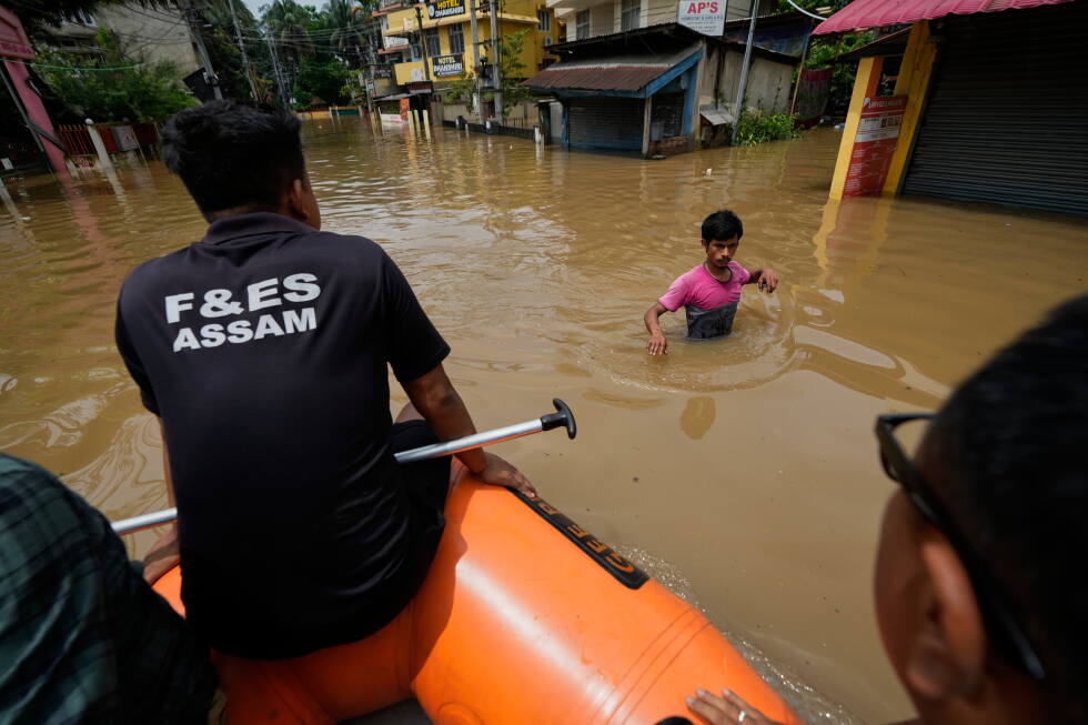
GUWAHATI, India — In the remote village of Hulang Katoni in India’s northeastern Assam state, what began as a routine errand on July 19 ended in a devastating loss. When heavy monsoon rains cut power to his home, Rojo Neog set out on his bicycle to buy candles. By the time he headed back, the swelling Dikhow River, a major tributary of the Brahmaputra, had surged beyond its banks with terrifying speed. Floodwaters tore Neog away, and his family recovered his body three days later.
Neog’s death is one of more than 100 fatalities linked to this year’s catastrophic flooding in Assam, an event state officials have labeled the worst the region has seen in nearly 60 years. For Neog’s niece Priyakshi Gogoi, the disaster was not just deadly, it was shockingly sudden. Flood levels near the village jumped from knee-deep to neck-deep in just 30 minutes, she said, and no advance warning reached the community. “In the morning we thought it’s fine, there is little flooding but it will subside, but we didn’t expect it to become so bad,” Gogoi told reporters.
The tragedy repeats across hundreds of flood-ravaged communities in Assam. Just kilometers away in Nepalikhuti village, 42-year-old Krishna Karamkar lost his life saving his 12-year-old son, who had accidentally stepped into the churning overflowing Dikhow. Karamkar pulled his son to safety but was swept away by the powerful current, leaving his wife Sumi Karamkar to navigate an uncertain future. “I have received some assistance from the government but that’s not enough. Our family’s future has suddenly become so uncertain,” she said. Nepalikhuti is one of the hardest-hit villages, reporting more than 1,000 livestock washed away and 200 homes completely destroyed.
Across the state, the full scale of the disaster is staggering: more than 700,000 people have been displaced, thousands are still sheltering in overcrowded relief camps even as waters slowly recede, vast swathes of farmland have been submerged, and critical road and utility infrastructure has been heavily damaged. Local resident Shravan Kumar, 26, from Bihubor village, described rushing his elderly parents to higher ground before returning with five small boats to rescue trapped neighbors. “People were clinging to trees, and rescuers had to break through a home’s roof to pull out two children and their parents,” Kumar said. “I have grown up in the area and have never seen such severe flooding before.”
For dairy farmer Prakash Sharma in Nepalikhuti, the surge caught the village completely off guard. By 10 a.m. on the day the flood hit, the only road connecting the village to the outside world was already underwater. By mid-afternoon, the entire settlement sat under roughly 9 feet of churning water, forcing residents to climb to rooftops and tree canopies for safety. Rescuers pulled Sharma and his family out that same day, but he is still reckoning with catastrophic losses. “For me, it was not just floods, it was a natural calamity of humongous proportion we had never seen before,” he said.
While seasonal flooding during the June-to-September monsoon has long been a fact of life in Assam — where roughly 40% of the land is inherently vulnerable to inundation from the Brahmaputra river system — climate and disaster experts warn that floods are growing far more unpredictable, destructive, and deadly due to a mix of human-caused climate change and harmful land use practices. Each year, monsoons bring critical moisture that cools the country, irrigates farms, and replenishes river systems, but rising global temperatures have made rainfall far more erratic and intense, creating the conditions for extreme flood events. India, one of the world’s top greenhouse gas emitters, is also one of the countries most vulnerable to the accelerating impacts of climate change.
A recent analysis from World Weather Attribution (WWA) confirmed that unplanned rapid urbanization, upstream deforestation, unregulated sand mining, widespread wetland loss, and overreliance on hard engineering flood control structures have dramatically worsened risk across Assam and neighboring northeastern states. The Brahmaputra and its tributaries naturally carry massive volumes of sediment eroded from the Himalayas, constantly reshaping their channels, banks, and river islands, meaning seasonal flooding can never be fully eliminated. But human alteration of the natural landscape has overwhelmed the river system’s capacity to absorb heavy rain, leaving communities with almost no time to react when waters surge.
For decades, Assam has poured millions of dollars into building embankments, flood walls, and erosion-control structures to hold back rivers. Experts agree this infrastructure still serves a purpose in densely populated areas, but they warn it creates new risks when it replaces natural flood absorption systems like forests, wetlands, and floodplains. While India has expanded national flood forecasting and early warning systems in recent years, researchers say critical gaps remain: warnings often get stuck in government bureaucracy and never reach at-risk rural communities, and even when alerts are delivered, there is rarely sufficient preparedness planning or accessible safe shelter for residents.
“India is very good at rescuing people or providing relief after the disaster, but is particularly bad in doing anything significant to reduce the possibilities of such disasters,” said Himanshu Thakkar, coordinator of the South Asia Network on Dams, Rivers and People, an environmental advocacy group. “It’s very important to study and understand flood risks better in Assam. Once we understand, we can also forecast well. Then we can prepare well and less people will be affected.”
Experts are now calling for a fundamental paradigm shift in how India manages flood risk, moving beyond a focus on building infrastructure to control rivers toward a strategy of working with natural systems and living with seasonal flooding. “True adaptation requires moving towards living with rivers through wetland restoration and proactive early action before floodwaters strike,” said Emmanuel Raju, director of the Copenhagen Centre for Disaster Research at the University of Copenhagen and a co-author of the WWA report.
Independent researcher Mirza Zulfiqar Rahman, who has spent years studying the Brahmaputra basin, noted that flood risk management must cross administrative boundaries, since upstream changes including deforestation, mining, and urban development directly impact downstream water flow and sediment levels in Assam. “Flood planning should follow the natural contours of river basins rather than state and international borders,” he said, adding that disaster policy remains far too focused on post-flood response rather than pre-flood risk reduction.
Climate change is already pushing flood events beyond the adaptive limits of communities that have lived with seasonal inundation for centuries, said Nihal Ranjit, a climate and disaster expert at the Indian Institute for Human Settlements. Historically, communities in flood-prone areas structured their farming and daily routines around seasonal flooding, but more frequent extreme events are making that traditional adaptation unworkable, driving rising displacement. “This always existed, but climate change and climate impacts like floods are increasing this movement,” Ranjit noted.
Reporting for this story was contributed by Sibi Arasu from Bengaluru, India. The Associated Press’ climate and environmental coverage receives financial support from multiple private foundations, with AP retaining full editorial control over all content.