Strung along Iran’s northern Gulf coast and clustered around the critical Strait of Hormuz, Iran’s roughly 400 islands have emerged as unexpected focal points of geopolitical turmoil amid escalating regional tensions linked to the US-Israeli war. While the vast majority of these landmasses are tiny, uninhabited outcrops, a handful of larger, strategically positioned islands carry enormous economic, military, and cultural significance that shapes both Iranian national security and global energy markets.
The Strait of Hormuz, the narrow waterway that links the Persian Gulf to the Gulf of Oman and the wider Indian Ocean, is universally recognized as the world’s most critical energy chokepoint. Approximately one-fifth of the global supply of oil and liquefied natural gas transits this corridor each year, making control over its surrounding islands a core priority for Iran’s military and strategic planning. In response to escalating tensions tied to the US-Israeli war, Iran has effectively moved to restrict access to parts of the strait, with its network of Gulf islands forming the backbone of its asymmetric maritime defense tactics.
Beyond their strategic military value, these islands underpin Iran’s core energy and tourism sectors, and hold millennia of layered human history, mirroring the rich cultural heritage of mainland Iran. Among them, three are mired in a long-running sovereignty dispute with the United Arab Emirates, one is famed for its unique community of female fishing breadwinners, and another is the site of one of the most high-profile missing person cases in modern Middle Eastern history. Middle East Eye’s deep dive into nine of Iran’s most notable Gulf islands reveals their outsized influence on regional and global affairs.
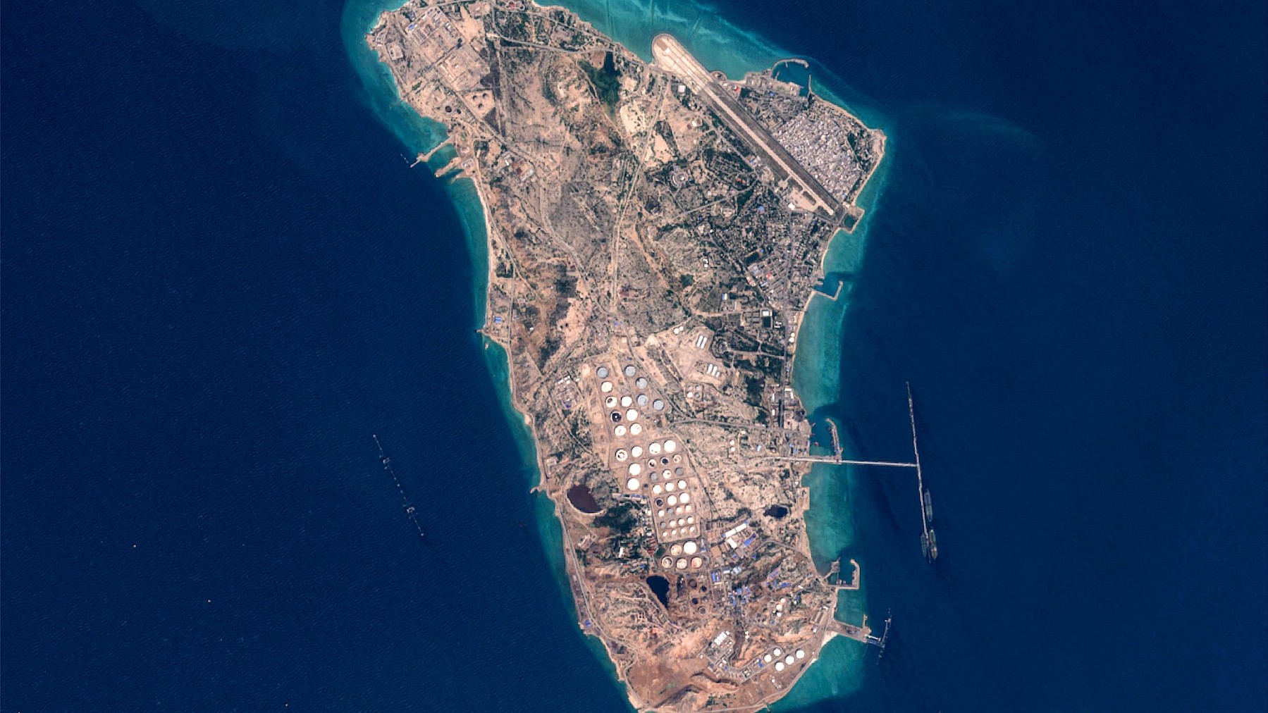
Kharg Island stands as the operational heart of Iran’s crude oil export infrastructure. Sitting 30 kilometers off the northern Gulf coast, the island processes and ships roughly 90 percent of Iran’s total crude oil exports to global markets. Crude pumped from oilfields across mainland Iran is transported via an extensive pipeline network to Kharg’s massive storage facilities and loading jetties, where it can hold up to 30 million barrels of oil — a stockpile that reportedly stood at around 18 million barrels last month.
Access to Kharg is tightly restricted by the Islamic Revolutionary Guard Corps (IRGC), earning it the nickname the “Forbidden Island,” with entry limited exclusively to individuals holding official security clearance. Most of the island’s 8,000 permanent residents work in the oil sector, but the land also hosts a wealth of archaeological treasures, including the ruins of an early Christian monastery, Sassanid-era burial mounds, and Achaemenid inscriptions dating back more than 2,300 years. Kharg has born the brunt of past conflicts: Iraqi air forces repeatedly targeted the terminal during the 1980s Iran-Iraq War, and in recent weeks, the US has launched strikes on what it says are 90 military targets on the island. Former US President Donald Trump has also publicly threatened to seize Kharg outright.
At 1,400 square kilometers, Qeshm is the largest island in the entire Persian Gulf. Part of Iran’s Hormozgan province, it sits in the Strait of Hormuz, just off the mainland port of Bandar Abbas. Home to roughly 150,000 residents, most of whom are Sunni Muslims who speak the local Bandari dialect, Qeshm has been a strategic military outpost for centuries, with both Portuguese and British colonial powers building naval bases on the island.
Today, Qeshm’s combination of historic landmarks and extraordinary ecological diversity have made it one of Iran’s top tourist destinations, and it is currently on UNESCO’s tentative World Heritage list. Following the 1979 Islamic Revolution, Qeshm was designated a free trade and industrial zone, with a unique tax and regulatory framework separate from the rest of Iran. It has also been developed as a core hub for Iran’s asymmetric maritime warfare capabilities, with intelligence sources confirming the IRGC has built a classified underground “missile city” on the island, housing submarines, fast attack craft, and coastal missile batteries. In March 2025, Iran accused the US of carrying out a strike on a desalination plant on Qeshm, a claim both Washington and Tel Aviv denied.
Hormuz Island, which shares its name with the strait it occupies, traces its title back to the ancient Kingdom of Hormuz, a dominant Gulf maritime power that controlled parts of modern-day Iran, Oman, and Bahrain between the 11th and 17th centuries. The kingdom made Hormuz Island its capital, turning it into a thriving trading crossroads between the Gulf and Indian Ocean. The island was later conquered by the Portuguese Empire, before eventually coming under joint Persian and British control. Today, Hormuz is a popular tourist destination famed for its otherworldly geological features: it is often called the “Rainbow Island” thanks to its vividly colored rock formations, ochre-tinted streams, red-sand beaches, and mountains streaked in pink, gold, and yellow hues.
Larak Island, positioned to the east of Qeshm and south of Hormuz Island, is the linchpin of Iran’s claim to control over the Strait of Hormuz. Iran has heavily fortified the island with a network of underground bunkers and bases for fast attack craft, allowing it to monitor all traffic passing through the strait and threaten commercial vessels if needed. In recent weeks, Larak has been central to Iran’s new shipping regime that has turned the strait into a de-facto tollbooth: shipping analysts have recorded that most commercial vessels now avoid the main shipping channel between Larak and Oman’s Musandam Peninsula, instead diverting north of Larak into a so-called “safe corridor” established by Iran for vessel inspections. According to shipping publication Lloyd’s List, one commercial vessel reportedly paid a $2 million fee to access the corridor, though it remains unclear if all vessels are charged.
Abu Musa is the largest and only inhabited of three Iranian-administered Gulf islands claimed by the United Arab Emirates. Covering just five square kilometers and home to around 2,000 residents, it is the farthest of Hormozgan province’s 14 islands from the Iranian mainland. The sovereignty dispute over the island dates back to the turn of the 20th century: when the Trucial States, the UAE’s precursor, became a British protectorate in the late 1800s, the emirate of Sharjah administered Abu Musa. Iran contested this claim, briefly planting its flag on the island in 1904 before withdrawing under British pressure, and the island remained under Sharjah’s control for decades.
When Britain withdrew from the Gulf in 1971, it brokered a deal to place Abu Musa under joint administration by Sharjah and Iran. But just two days before the UAE declared full independence on November 30 1971, Iranian forces seized full control of the island. A week later, the UAE brought the dispute to the UN Security Council, and has pursued a diplomatic resolution for the island and the nearby Greater and Lesser Tunbs for more than 50 years. Iran argues its sovereignty over the three islands dates back to the Persian Empire of the 6th century BCE, and has cited a 19th-century British map to back its territorial claims. Today, Abu Musa serves as Iran’s forward defense outpost in the Strait of Hormuz, and US media reports indicate the Pentagon has considered seizing the island as an option for a “final blow” against Iran amid current tensions.
The Greater and Lesser Tunbs, two small uninhabited islands near the Strait of Hormuz, are also claimed by the UAE — specifically by the emirate of Ras al-Khaimah. Unlike Abu Musa, no tentative agreement was reached between Iran and Ras al-Khaimah before Britain’s 1971 withdrawal. When Iranian troops landed on Greater Tunb that November, the six-person local police force opened fire on the 30-member Iranian detachment. The ensuing shootout killed three Iranian personnel and four Emirati police officers. Greater Tunb covers four square kilometers, while Lesser Tunb is less than one square kilometer in size; according to CIA intelligence, Lesser Tunb is overrun by venomous sea snakes. Iran has equipped both islands with missiles, drones, and mine-laying capabilities, according to regional defense analysts.
Hengam Island, a 36-square-kilometer landmass sitting just two kilometers off the coast of Qeshm, is home to only a few hundred families spread across three small villages. Like neighboring islands, it served as a colonial military outpost for both Portugal and Britain. Today, it is best known for its long-standing community of veiled fisherwomen, who are the primary breadwinners for their households. A 2021 feature in *The New Yorker* described the group as “the only fisherwomen in Iran – and probably in the eight other countries around the Gulf.”
Kish Island is Iran’s most popular tourist resort, drawing millions of domestic and international visitors every year. Renowned for its white-sand beaches, luxury resort hotels, and large shopping centers, Kish is also a free trade zone like Qeshm, and is the only part of Iran that allows foreign visitors to enter without a visa. The island gained international infamy as the site where former FBI agent Robert Levinson disappeared during a visit in March 2007. The case remains unsolved, though the US government says it has credible evidence that Levinson died in Iranian captivity by 2020.
Kish has also been the site of small high-profile incidents: in 2019, British singer Joss Stone was denied entry to the island despite the visa waiver, with Iranian officials citing incorrect documentation. Stone has said she believes she was barred because authorities suspected she would violate rules banning women from performing solo public concerts. On the first day of the recent escalation of conflict, footage emerged showing smoke rising from a US-Israeli strike on targets on Kish.