U.S. climate scientists have officially confirmed the formation of a new El Niño event, a naturally occurring climate pattern capable of triggering extreme weather disruptions across every inhabited continent, with forecasts indicating it could rank among the most intense events recorded since 1950.
The National Oceanic and Atmospheric Administration (NOAA) announced the onset of the new El Niño phase after detecting consistent sea surface temperature anomalies of more than 0.5°C above long-term averages across the central tropical Pacific, paired with a measurable shift in atmospheric pressure: lower pressure over the central Pacific and higher pressure in the western Pacific. The Japanese Meteorological Agency has independently verified the presence of El Niño conditions, matching NOAA’s findings.
What makes this event particularly concerning to researchers is the unusually high temperature of sub-surface Pacific waters, which have measured up to 6°C above average in some regions, per data from the United Nations’ World Meteorological Organization (WMO). Historical climate patterns show that deep ocean heat typically rises to the surface over the course of an El Niño event, driving further warming. NOAA’s latest probability calculations put the chance of this El Niño reaching “very strong” or “super” status—defined as a sustained surface warming of 2°C or more across the central tropical Pacific—at 63%, meaning it will almost certainly rank among the most significant events in the modern observational record. The event is projected to persist at least through the early months of 2027.
First documented by Peruvian fishermen in the 1600s, who named the warm December current El Niño de Navidad (the Christ Child) for its seasonal timing, the climate pattern forms when trade winds that normally blow east to west across the tropical Pacific weaken or reverse direction, allowing warm surface water that usually accumulates near Australia and Southeast Asia to spread eastward toward the coasts of North and South America.
When combined with decades of anthropogenic global warming, this new El Niño is expected to push 2027 to become the hottest year ever recorded on a global scale. “El Niño conditions will pour fuel on the fire of a warming world. Impacts will hit even harder, travel even farther, and cross borders with devastating speed,” U.N. Secretary-General António Guterres warned, urging nations to begin preparation for widespread disruptions immediately.
WMO Secretary-General Celeste Saulo added that a strong El Niño will exacerbate already dangerous climate extremes, worsening droughts, extreme rainfall events, and heatwaves on both land and ocean as the Pacific transfers accumulated heat into the atmosphere.
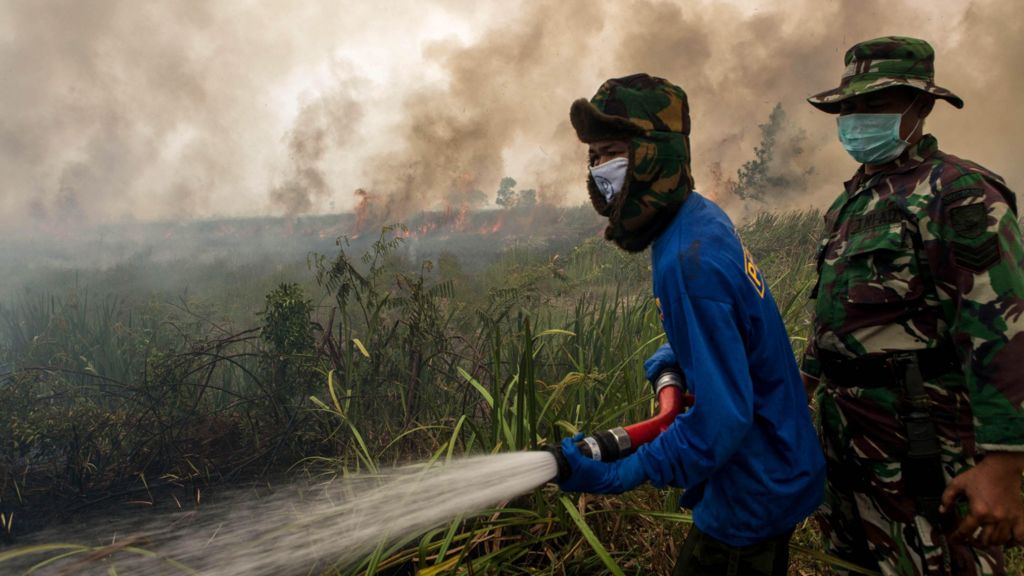
While no two El Niño events produce identical impacts, consistent historical trends outline broad regional effects. A strong event typically brings prolonged hot, dry conditions to parts of South America, Southeast Asia, and Australia, dramatically increasing the risk of severe droughts and destructive wildfires—conditions that mirror the devastating blazes that swept across Indonesia during the record 2015-16 El Niño event. It also tends to weaken the critical Indian monsoon, reducing rainfall across South Asia. In the southern United States, El Niño amplifies rainfall, raising the probability of life-threatening flooding. For tropical storm activity, the pattern increases cyclone formation in the eastern and central Pacific while suppressing activity in the tropical Atlantic, including off the southeastern U.S. coast. The impact on U.K. weather is less consistent, but the U.K. Met Office notes El Niño often increases the chance of a mild early winter followed by a cold late winter.
Beyond immediate weather disruptions, the event poses serious risks to global food security. Droughts in major agricultural regions of South America and Southeast Asia could reduce crop yields at a time when global fertilizer distribution is already disrupted by the effective closure of the Strait of Hormuz. A smaller harvest would tighten already strained global food supplies and push prices higher, worsening food insecurity for vulnerable populations. For South American fishing communities, the event reduces the upwelling of cold, nutrient-rich water that sustains popular commercial species such as anchovies, leading to smaller catches and economic hardship.
Many researchers are drawing parallels to the 2015-16 El Niño, one of the strongest events on record. That event caused widespread water shortages in the Caribbean, a record-breaking tropical storm season in the central Pacific, and prolonged drought in the Horn of Africa. The U.N. Food and Agriculture Organization estimates that the combined climate shocks linked to that event left millions of people across the globe facing food insecurity.
The Intergovernmental Panel on Climate Change (IPCC) has noted that El Niño events recorded since 1950 have been stronger on average than events between 1850 and 1950, though historical data from tree rings confirms that frequency and intensity have varied naturally since the 1400s. There is currently no clear scientific consensus that anthropogenic climate change has altered the frequency or intensity of El Niño events, though some climate models project that El Niños may become more frequent and more intense as global warming continues. Regardless of its link to climate change, this El Niño’s impacts will be amplified by the long-term warming driven by greenhouse gas emissions, making extreme weather more dangerous than it would have been in a pre-warming world.
El Niño is the warm phase of the Pacific’s natural ENSO (El Niño-Southern Oscillation) cycle, paired with its cooler counterpart La Niña. During La Niña events, central-eastern Pacific surface temperatures fall below average and atmospheric pressure patterns reverse, bringing wetter conditions to Australia, Indonesia, and equatorial South America and drier conditions to the southern U.S. El Niño and La Niña typically alternate, though repeated back-to-back events of the same phase are not uncommon. On average, the full ENSO cycle produces an El Niño or La Niña every two to seven years.